You are here: Home > Network List > TS - TERRAscope (Southern California Seismic Network) Stations List
> Station PFO Pinon Flat, California, USA > Earthquake Result Viewer
PFO Pinon Flat, California, USA - Earthquake Result Viewer
| Earthquake location: |
Santiago Del Estero Prov., Arg. |
| Earthquake latitude/longitude: |
-28.5/-63.1 |
| Earthquake time(UTC): |
1994/05/10 (130) 06:36:28 GMT |
| Earthquake Depth: |
605 km |
| Earthquake Magnitude: |
6.4 MB, 6.2 UNKNOWN, 6.9 MW |
| Earthquake Catalog/Contributor: |
WHDF/NEIC |
|
| Network: |
TS TERRAscope (Southern California Seismic Network) |
| Station: |
PFO Pinon Flat, California, USA |
| Lat/Lon: |
33.61 N/116.46 W |
| Elevation: |
1280 m |
|
| Distance: |
79.8 deg |
| Az: |
317.107 deg |
| Baz: |
134.123 deg |
| Ray Param: |
0.04680925 |
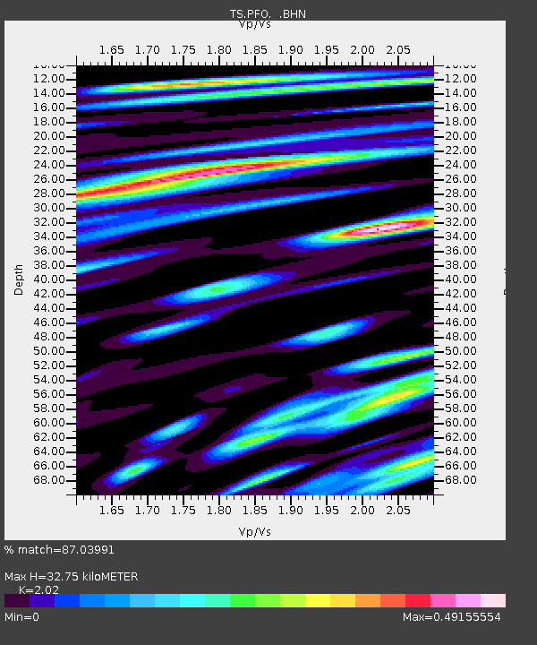
| Estimated Moho Depth: |
32.75 km |
| Estimated Crust Vp/Vs: |
2.02 |
| Assumed Crust Vp: |
6.264 km/s |
| Estimated Crust Vs: |
3.101 km/s |
| Estimated Crust Poisson's Ratio: |
0.34 |
|
| Radial Match: |
87.03991 % |
| Radial Bump: |
400 |
| Transverse Match: |
82.367355 % |
| Transverse Bump: |
400 |
| SOD ConfigId: |
16938 |
| Insert Time: |
2010-02-26 14:42:38.189 +0000 |
| GWidth: |
2.5 |
| Max Bumps: |
400 |
| Tol: |
0.001 |
|
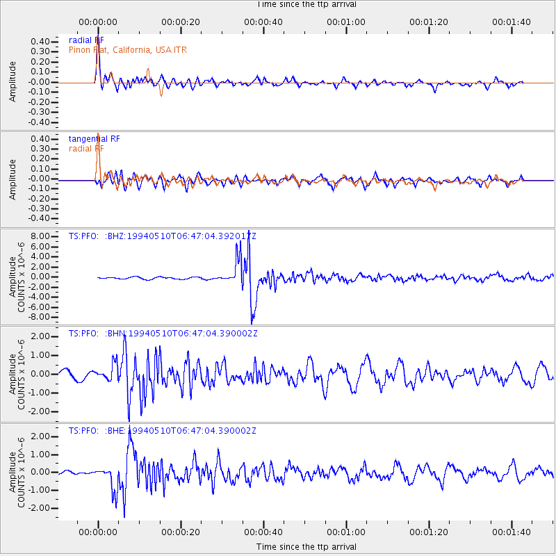
Signal To Noise
| Channel | StoN | STA | LTA |
| TS:PFO: :BHN:19940510T06:47:04.390002Z | 1.6163901 | 4.4251067E-7 | 2.7376478E-7 |
| TS:PFO: :BHE:19940510T06:47:04.390002Z | 7.213811 | 7.049415E-7 | 9.772109E-8 |
| TS:PFO: :BHZ:19940510T06:47:04.392017Z | 12.7799635 | 2.6096818E-6 | 2.0420104E-7 |
| Arrivals |
| Ps | 5.5 SECOND |
| PpPs | 15 SECOND |
| PsPs/PpSs | 21 SECOND |


