You are here: Home > Network List > MN - MEDNET Project Stations List
> Station VTS Vitosha, Bulgary > Earthquake Result Viewer
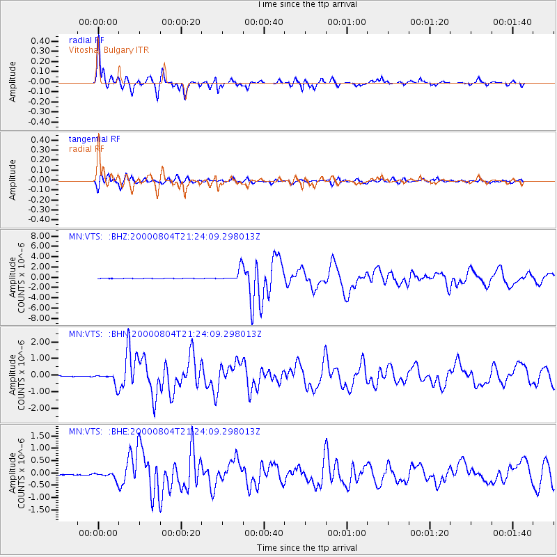
VTS Vitosha, Bulgary - Earthquake Result Viewer

| Earthquake location: |
Sakhalin, Russia |
| Earthquake latitude/longitude: |
48.8/142.2 |
| Earthquake time(UTC): |
2000/08/04 (217) 21:13:02 GMT |
| Earthquake Depth: |
10 km |
| Earthquake Magnitude: |
6.3 MB, 7.1 MS, 6.8 MW, 6.7 MW |
| Earthquake Catalog/Contributor: |
WHDF/NEIC |
|
| Network: |
MN MEDNET Project |
| Station: |
VTS Vitosha, Bulgary |
| Lat/Lon: |
42.62 N/23.24 E |
| Elevation: |
1490 m |
|
| Distance: |
74.4 deg |
| Az: |
317.911 deg |
| Baz: |
36.911 deg |
| Ray Param: |
0.05237251 |
| Estimated Moho Depth: |
12.0 km |
| Estimated Crust Vp/Vs: |
1.66 |
| Assumed Crust Vp: |
6.291 km/s |
| Estimated Crust Vs: |
3.796 km/s |
| Estimated Crust Poisson's Ratio: |
0.21 |
|
| Radial Match: |
96.40553 % |
| Radial Bump: |
330 |
| Transverse Match: |
88.1932 % |
| Transverse Bump: |
400 |
| SOD ConfigId: |
3744 |
| Insert Time: |
2010-03-08 17:52:33.999 +0000 |
| GWidth: |
2.5 |
| Max Bumps: |
400 |
| Tol: |
0.001 |
|
Signal To Noise
| Channel | StoN | STA | LTA |
| MN:VTS: :BHN:20000804T21:24:09.298013Z | 8.194263 | 4.0829238E-7 | 4.982661E-8 |
| MN:VTS: :BHE:20000804T21:24:09.298013Z | 2.5274124 | 1.714779E-7 | 6.784721E-8 |
| MN:VTS: :BHZ:20000804T21:24:09.298013Z | 31.659027 | 1.3551492E-6 | 4.2804512E-8 |
| Arrivals |
| Ps | 1.3 SECOND |
| PpPs | 4.9 SECOND |
| PsPs/PpSs | 6.2 SECOND |


