You are here: Home > Network List > TS - TERRAscope (Southern California Seismic Network) Stations List
> Station PFO Pinon Flat, California, USA > Earthquake Result Viewer
PFO Pinon Flat, California, USA - Earthquake Result Viewer
| Earthquake location: |
Northern Bolivia |
| Earthquake latitude/longitude: |
-13.8/-67.6 |
| Earthquake time(UTC): |
1994/06/09 (160) 00:33:16 GMT |
| Earthquake Depth: |
637 km |
| Earthquake Magnitude: |
6.9 MB, 6.8 MS, 8.3 UNKNOWN, 8.2 MW |
| Earthquake Catalog/Contributor: |
WHDF/NEIC |
|
| Network: |
TS TERRAscope (Southern California Seismic Network) |
| Station: |
PFO Pinon Flat, California, USA |
| Lat/Lon: |
33.61 N/116.46 W |
| Elevation: |
1280 m |
|
| Distance: |
66.3 deg |
| Az: |
316.626 deg |
| Baz: |
126.931 deg |
| Ray Param: |
0.05532372 |
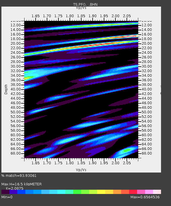
| Estimated Moho Depth: |
16.5 km |
| Estimated Crust Vp/Vs: |
2.09 |
| Assumed Crust Vp: |
6.264 km/s |
| Estimated Crust Vs: |
3.001 km/s |
| Estimated Crust Poisson's Ratio: |
0.35 |
|
| Radial Match: |
93.93061 % |
| Radial Bump: |
386 |
| Transverse Match: |
88.89001 % |
| Transverse Bump: |
400 |
| SOD ConfigId: |
16938 |
| Insert Time: |
2010-02-26 14:42:40.503 +0000 |
| GWidth: |
2.5 |
| Max Bumps: |
400 |
| Tol: |
0.001 |
|
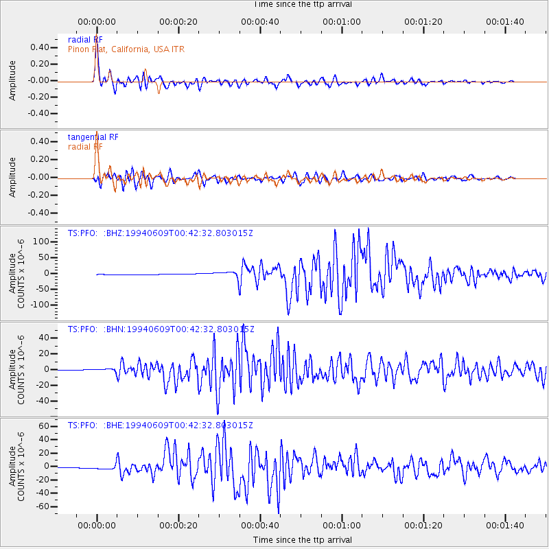
Signal To Noise
| Channel | StoN | STA | LTA |
| TS:PFO: :BHN:19940609T00:42:32.803015Z | 10.924932 | 1.9431677E-6 | 1.7786545E-7 |
| TS:PFO: :BHE:19940609T00:42:32.803015Z | 12.070378 | 3.5034577E-6 | 2.9025253E-7 |
| TS:PFO: :BHZ:19940609T00:42:32.803015Z | 13.952163 | 1.0354488E-5 | 7.4214216E-7 |
| Arrivals |
| Ps | 3.0 SECOND |
| PpPs | 7.9 SECOND |
| PsPs/PpSs | 11 SECOND |


