You are here: Home > Network List > JP - Japan Meteorological Agency Seismic Network Stations List
> Station JWT Kyoto Wachi > Earthquake Result Viewer
JWT Kyoto Wachi - Earthquake Result Viewer
| Earthquake location: |
Mindanao, Philippines |
| Earthquake latitude/longitude: |
5.5/126.5 |
| Earthquake time(UTC): |
2020/02/06 (037) 13:40:09 GMT |
| Earthquake Depth: |
44 km |
| Earthquake Magnitude: |
6.0 Mww |
| Earthquake Catalog/Contributor: |
NEIC PDE/us |
|
| Network: |
JP Japan Meteorological Agency Seismic Network |
| Station: |
JWT Kyoto Wachi |
| Lat/Lon: |
35.29 N/135.40 E |
| Elevation: |
172 m |
|
| Distance: |
30.8 deg |
| Az: |
14.323 deg |
| Baz: |
197.52 deg |
| Ray Param: |
0.0792434 |
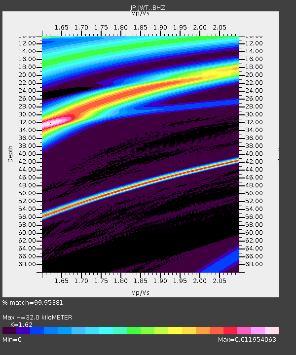
| Estimated Moho Depth: |
32.0 km |
| Estimated Crust Vp/Vs: |
1.62 |
| Assumed Crust Vp: |
6.468 km/s |
| Estimated Crust Vs: |
3.992 km/s |
| Estimated Crust Poisson's Ratio: |
0.19 |
|
| Radial Match: |
99.95381 % |
| Radial Bump: |
13 |
| Transverse Match: |
99.6983 % |
| Transverse Bump: |
40 |
| SOD ConfigId: |
20465011 |
| Insert Time: |
2020-02-24 13:17:45.158 +0000 |
| GWidth: |
2.5 |
| Max Bumps: |
400 |
| Tol: |
0.001 |
|

Signal To Noise
| Channel | StoN | STA | LTA |
| JP:JWT: :BHZ:20200206T13:45:50.550013Z | 0.6372018 | 1.0857706E-6 | 1.7039666E-6 |
| JP:JWT: :BHN:20200206T13:45:50.550013Z | 0.65708405 | 1.0842143E-6 | 1.650039E-6 |
| JP:JWT: :BHE:20200206T13:45:50.550013Z | 0.7206329 | 1.0852208E-6 | 1.5059273E-6 |
| Arrivals |
| Ps | 3.4 SECOND |
| PpPs | 12 SECOND |
| PsPs/PpSs | 15 SECOND |


