You are here: Home > Network List > TS - TERRAscope (Southern California Seismic Network) Stations List
> Station PFO Pinon Flat, California, USA > Earthquake Result Viewer
PFO Pinon Flat, California, USA - Earthquake Result Viewer
| Earthquake location: |
Santiago Del Estero Prov., Arg. |
| Earthquake latitude/longitude: |
-26.7/-63.4 |
| Earthquake time(UTC): |
1994/08/19 (231) 10:02:51 GMT |
| Earthquake Depth: |
565 km |
| Earthquake Magnitude: |
6.4 MB, 6.5 UNKNOWN, 6.5 MW |
| Earthquake Catalog/Contributor: |
WHDF/NEIC |
|
| Network: |
TS TERRAscope (Southern California Seismic Network) |
| Station: |
PFO Pinon Flat, California, USA |
| Lat/Lon: |
33.61 N/116.46 W |
| Elevation: |
1280 m |
|
| Distance: |
78.3 deg |
| Az: |
317.052 deg |
| Baz: |
133.059 deg |
| Ray Param: |
0.047994453 |
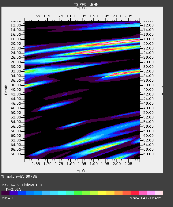
| Estimated Moho Depth: |
19.0 km |
| Estimated Crust Vp/Vs: |
2.02 |
| Assumed Crust Vp: |
6.264 km/s |
| Estimated Crust Vs: |
3.109 km/s |
| Estimated Crust Poisson's Ratio: |
0.34 |
|
| Radial Match: |
85.69738 % |
| Radial Bump: |
400 |
| Transverse Match: |
78.13527 % |
| Transverse Bump: |
400 |
| SOD ConfigId: |
16938 |
| Insert Time: |
2010-02-26 14:42:41.650 +0000 |
| GWidth: |
2.5 |
| Max Bumps: |
400 |
| Tol: |
0.001 |
|
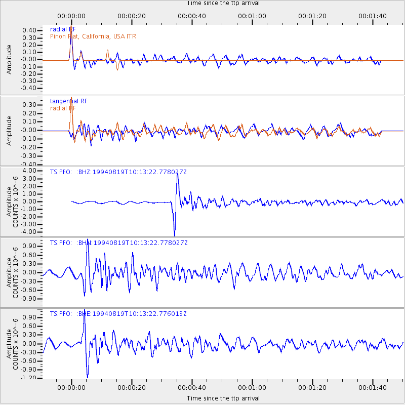
Signal To Noise
| Channel | StoN | STA | LTA |
| TS:PFO: :BHN:19940819T10:13:22.778027Z | 3.198387 | 2.5396463E-7 | 7.940397E-8 |
| TS:PFO: :BHE:19940819T10:13:22.776013Z | 2.6809726 | 3.4146157E-7 | 1.2736481E-7 |
| TS:PFO: :BHZ:19940819T10:13:22.778027Z | 11.484181 | 1.3049805E-6 | 1.1363287E-7 |
| Arrivals |
| Ps | 3.2 SECOND |
| PpPs | 8.9 SECOND |
| PsPs/PpSs | 12 SECOND |


