You are here: Home > Network List > MN - MEDNET Project Stations List
> Station VTS Vitosha, Bulgary > Earthquake Result Viewer
VTS Vitosha, Bulgary - Earthquake Result Viewer

| Earthquake location: |
Hokkaido, Japan Region |
| Earthquake latitude/longitude: |
41.0/142.3 |
| Earthquake time(UTC): |
2001/08/13 (225) 20:11:23 GMT |
| Earthquake Depth: |
38 km |
| Earthquake Magnitude: |
6.0 MB, 6.3 MS, 6.4 MW, 6.3 ME |
| Earthquake Catalog/Contributor: |
WHDF/NEIC |
|
| Network: |
MN MEDNET Project |
| Station: |
VTS Vitosha, Bulgary |
| Lat/Lon: |
42.62 N/23.24 E |
| Elevation: |
1490 m |
|
| Distance: |
80.2 deg |
| Az: |
319.105 deg |
| Baz: |
42.131 deg |
| Ray Param: |
0.04837502 |
| Estimated Moho Depth: |
35.0 km |
| Estimated Crust Vp/Vs: |
1.91 |
| Assumed Crust Vp: |
6.291 km/s |
| Estimated Crust Vs: |
3.294 km/s |
| Estimated Crust Poisson's Ratio: |
0.31 |
|
| Radial Match: |
94.96836 % |
| Radial Bump: |
382 |
| Transverse Match: |
92.85966 % |
| Transverse Bump: |
400 |
| SOD ConfigId: |
20082 |
| Insert Time: |
2010-03-08 17:53:09.880 +0000 |
| GWidth: |
2.5 |
| Max Bumps: |
400 |
| Tol: |
0.001 |
|
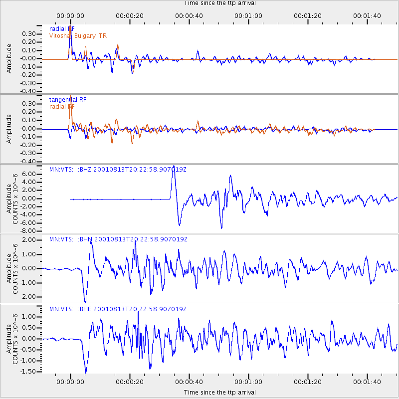
Signal To Noise
| Channel | StoN | STA | LTA |
| MN:VTS: :BHN:20010813T20:22:58.907019Z | 19.138569 | 6.7977584E-7 | 3.5518635E-8 |
| MN:VTS: :BHE:20010813T20:22:58.907019Z | 8.113604 | 3.5028418E-7 | 4.3172456E-8 |
| MN:VTS: :BHZ:20010813T20:22:58.907019Z | 58.945244 | 2.5700015E-6 | 4.3599808E-8 |
| Arrivals |
| Ps | 5.2 SECOND |
| PpPs | 16 SECOND |
| PsPs/PpSs | 21 SECOND |


