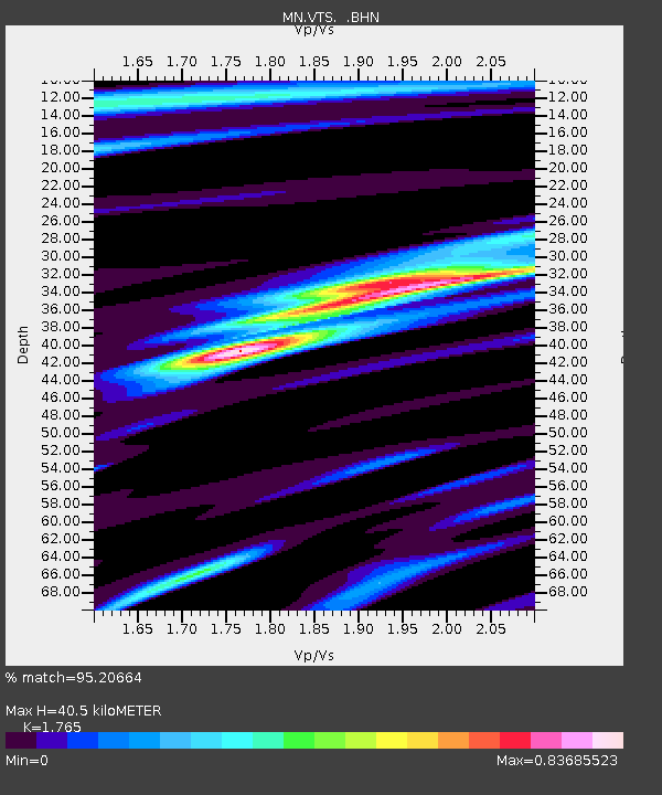
VTS Vitosha, Bulgary - Earthquake Result Viewer

Earthquake location: Kodiak Island Region, Alaska
Earthquake latitude/longitude: 57.1/-153.2
Earthquake time(UTC): 2001/01/10 (010) 16:02:44 GMT
Earthquake Depth: 33 km
Earthquake Magnitude: 6.2 MB, 6.8 MS, 7.1 MW, 6.8 ML
Earthquake Catalog/Contributor: WHDF/NEIC
Network: MN MEDNET Project
Station: VTS Vitosha, Bulgary
Lat/Lon: 42.62 N/23.24 E
Elevation: 1490 m
Distance: 80.6 deg
Az: 2.658 deg
Baz: 358.034 deg
Ray Param: 0.04810428
Estimated Moho Depth: 40.5 km
Estimated Crust Vp/Vs: 1.76
Assumed Crust Vp: 6.291 km/s
Estimated Crust Vs: 3.564 km/s
Estimated Crust Poisson's Ratio: 0.26
Radial Match: 95.20664 %
Radial Bump: 400
Transverse Match: 92.1562 %
Transverse Bump: 400
SOD ConfigId: 3744
Insert Time: 2010-03-08 17:53:18.604 +0000
GWidth: 2.5
Max Bumps: 400
Tol: 0.001

Signal To Noise

ChannelStoNSTALTA
MN:VTS: :BHN:20010110T16:14:22.513997Z9.929836.778595E-76.826497E-8
MN:VTS: :BHE:20010110T16:14:22.513997Z2.9420461.4201241E-74.826995E-8
MN:VTS: :BHZ:20010110T16:14:22.513997Z21.8555851.8915135E-68.6546E-8
Arrivals
Ps5.1 SECOND
PpPs17 SECOND
PsPs/PpSs22 SECOND