You are here: Home > Network List > US - United States National Seismic Network Stations List
> Station HLID Hailey, Idaho, USA > Earthquake Result Viewer
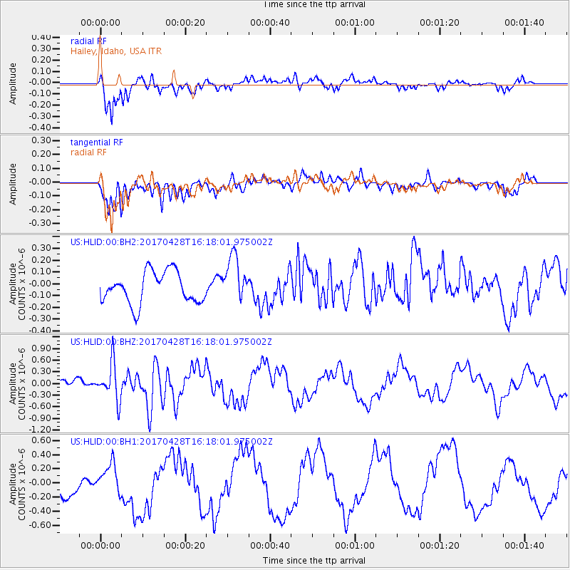
HLID Hailey, Idaho, USA - Earthquake Result Viewer
*The percent match for this event was below the threshold and hence no stack was calculated.
| Earthquake location: |
Near Coast Of Central Chile |
| Earthquake latitude/longitude: |
-33.1/-71.8 |
| Earthquake time(UTC): |
2017/04/28 (118) 16:05:55 GMT |
| Earthquake Depth: |
14 km |
| Earthquake Magnitude: |
5.7 Mww |
| Earthquake Catalog/Contributor: |
NEIC PDE/us |
|
| Network: |
US United States National Seismic Network |
| Station: |
HLID Hailey, Idaho, USA |
| Lat/Lon: |
43.56 N/114.41 W |
| Elevation: |
1772 m |
|
| Distance: |
85.7 deg |
| Az: |
330.438 deg |
| Baz: |
145.281 deg |
| Ray Param: |
$rayparam |
*The percent match for this event was below the threshold and hence was not used in the summary stack. |
|
| Radial Match: |
83.83499 % |
| Radial Bump: |
400 |
| Transverse Match: |
65.45038 % |
| Transverse Bump: |
400 |
| SOD ConfigId: |
2028011 |
| Insert Time: |
2017-05-12 16:23:24.493 +0000 |
| GWidth: |
2.5 |
| Max Bumps: |
400 |
| Tol: |
0.001 |
|
Signal To Noise
| Channel | StoN | STA | LTA |
| US:HLID:00:BHZ:20170428T16:18:01.975002Z | 4.43527 | 4.899897E-7 | 1.10475746E-7 |
| US:HLID:00:BH1:20170428T16:18:01.975002Z | 1.5314251 | 2.0740669E-7 | 1.3543378E-7 |
| US:HLID:00:BH2:20170428T16:18:01.975002Z | 1.4955928 | 1.9851088E-7 | 1.3273056E-7 |
| Arrivals |
| Ps | |
| PpPs | |
| PsPs/PpSs | |


