You are here: Home > Network List > TS - TERRAscope (Southern California Seismic Network) Stations List
> Station PFO Pinon Flat, California, USA > Earthquake Result Viewer
PFO Pinon Flat, California, USA - Earthquake Result Viewer
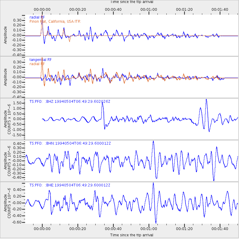
| Earthquake location: |
Vanuatu Islands |
| Earthquake latitude/longitude: |
-17.1/168.3 |
| Earthquake time(UTC): |
1994/05/04 (124) 06:37:37 GMT |
| Earthquake Depth: |
221 km |
| Earthquake Magnitude: |
5.7 MB |
| Earthquake Catalog/Contributor: |
WHDF/NEIC |
|
| Network: |
TS TERRAscope (Southern California Seismic Network) |
| Station: |
PFO Pinon Flat, California, USA |
| Lat/Lon: |
33.61 N/116.46 W |
| Elevation: |
1280 m |
|
| Distance: |
87.6 deg |
| Az: |
53.887 deg |
| Baz: |
247.806 deg |
| Ray Param: |
0.042692795 |
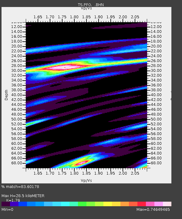
| Estimated Moho Depth: |
28.5 km |
| Estimated Crust Vp/Vs: |
1.76 |
| Assumed Crust Vp: |
6.264 km/s |
| Estimated Crust Vs: |
3.559 km/s |
| Estimated Crust Poisson's Ratio: |
0.26 |
|
| Radial Match: |
83.60178 % |
| Radial Bump: |
379 |
| Transverse Match: |
72.7347 % |
| Transverse Bump: |
400 |
| SOD ConfigId: |
17000 |
| Insert Time: |
2010-02-26 14:42:44.093 +0000 |
| GWidth: |
2.5 |
| Max Bumps: |
400 |
| Tol: |
0.001 |
|
Signal To Noise
| Channel | StoN | STA | LTA |
| TS:PFO: :BHN:19940504T06:49:29.600012Z | 1.0980741 | 8.209696E-8 | 7.476449E-8 |
| TS:PFO: :BHE:19940504T06:49:29.600012Z | 2.6299324 | 1.8138866E-7 | 6.897084E-8 |
| TS:PFO: :BHZ:19940504T06:49:29.602026Z | 5.2599087 | 5.898506E-7 | 1.1214084E-7 |
| Arrivals |
| Ps | 3.5 SECOND |
| PpPs | 12 SECOND |
| PsPs/PpSs | 16 SECOND |


