You are here: Home > Network List > C1 - Red Sismologica Nacional Stations List
> Station MT14 Calan > Earthquake Result Viewer
MT14 Calan - Earthquake Result Viewer
| Earthquake location: |
South Sandwich Islands Region |
| Earthquake latitude/longitude: |
-60.0/-25.5 |
| Earthquake time(UTC): |
2020/02/08 (039) 14:32:57 GMT |
| Earthquake Depth: |
16 km |
| Earthquake Magnitude: |
6.1 mww |
| Earthquake Catalog/Contributor: |
NEIC PDE/us |
|
| Network: |
C1 Red Sismologica Nacional |
| Station: |
MT14 Calan |
| Lat/Lon: |
33.40 S/70.54 W |
| Elevation: |
856 m |
|
| Distance: |
39.6 deg |
| Az: |
291.719 deg |
| Baz: |
146.099 deg |
| Ray Param: |
0.074879654 |
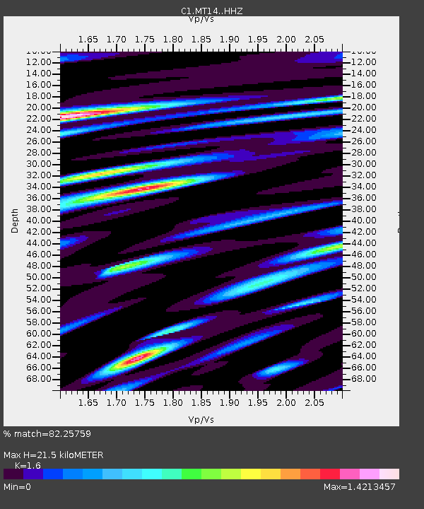
| Estimated Moho Depth: |
21.5 km |
| Estimated Crust Vp/Vs: |
1.60 |
| Assumed Crust Vp: |
6.481 km/s |
| Estimated Crust Vs: |
4.05 km/s |
| Estimated Crust Poisson's Ratio: |
0.18 |
|
| Radial Match: |
82.25759 % |
| Radial Bump: |
400 |
| Transverse Match: |
74.484375 % |
| Transverse Bump: |
400 |
| SOD ConfigId: |
20792311 |
| Insert Time: |
2020-02-29 22:32:10.861 +0000 |
| GWidth: |
2.5 |
| Max Bumps: |
400 |
| Tol: |
0.001 |
|

Signal To Noise
| Channel | StoN | STA | LTA |
| C1:MT14: :HHZ:20200208T14:39:57.30299Z | 5.280359 | 1.9243441E-6 | 3.6443433E-7 |
| C1:MT14: :HHN:20200208T14:39:57.30299Z | 3.4219282 | 1.1244726E-6 | 3.286079E-7 |
| C1:MT14: :HHE:20200208T14:39:57.30299Z | 1.3589106 | 5.296911E-7 | 3.8979098E-7 |
| Arrivals |
| Ps | 2.2 SECOND |
| PpPs | 8.0 SECOND |
| PsPs/PpSs | 10 SECOND |


