You are here: Home > Network List > GT - Global Telemetered Seismograph Network (USAF/USGS) Stations List
> Station LPAZ La Paz , Bolivia > Earthquake Result Viewer
LPAZ La Paz , Bolivia - Earthquake Result Viewer
| Earthquake location: |
South Sandwich Islands Region |
| Earthquake latitude/longitude: |
-60.0/-25.5 |
| Earthquake time(UTC): |
2020/02/08 (039) 14:32:57 GMT |
| Earthquake Depth: |
16 km |
| Earthquake Magnitude: |
6.1 mww |
| Earthquake Catalog/Contributor: |
NEIC PDE/us |
|
| Network: |
GT Global Telemetered Seismograph Network (USAF/USGS) |
| Station: |
LPAZ La Paz , Bolivia |
| Lat/Lon: |
16.17 S/68.08 W |
| Elevation: |
4817 m |
|
| Distance: |
53.5 deg |
| Az: |
306.005 deg |
| Baz: |
154.986 deg |
| Ray Param: |
0.06604707 |
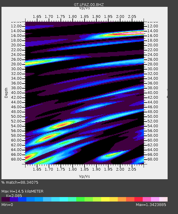
| Estimated Moho Depth: |
14.5 km |
| Estimated Crust Vp/Vs: |
2.09 |
| Assumed Crust Vp: |
6.454 km/s |
| Estimated Crust Vs: |
3.095 km/s |
| Estimated Crust Poisson's Ratio: |
0.35 |
|
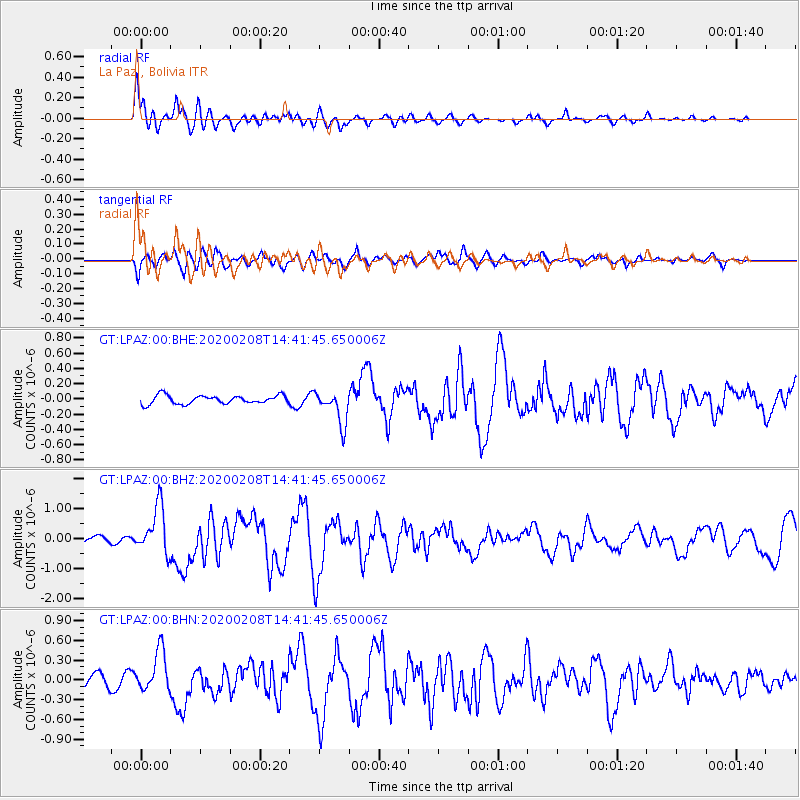
| Radial Match: |
88.34075 % |
| Radial Bump: |
400 |
| Transverse Match: |
78.07426 % |
| Transverse Bump: |
400 |
| SOD ConfigId: |
20792311 |
| Insert Time: |
2020-02-29 22:47:45.279 +0000 |
| GWidth: |
2.5 |
| Max Bumps: |
400 |
| Tol: |
0.001 |
|
Signal To Noise
| Channel | StoN | STA | LTA |
| GT:LPAZ:00:BHZ:20200208T14:41:45.650006Z | 9.205729 | 7.893364E-7 | 8.574404E-8 |
| GT:LPAZ:00:BHN:20200208T14:41:45.650006Z | 3.0685985 | 3.0911625E-7 | 1.0073532E-7 |
| GT:LPAZ:00:BHE:20200208T14:41:45.650006Z | 4.0030637 | 2.2223767E-7 | 5.5516896E-8 |
| Arrivals |
| Ps | 2.6 SECOND |
| PpPs | 6.6 SECOND |
| PsPs/PpSs | 9.2 SECOND |


