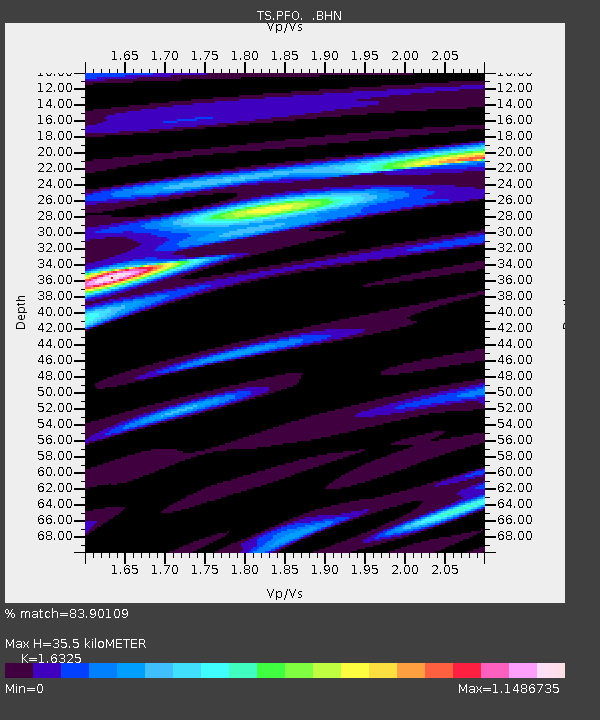
PFO Pinon Flat, California, USA - Earthquake Result Viewer
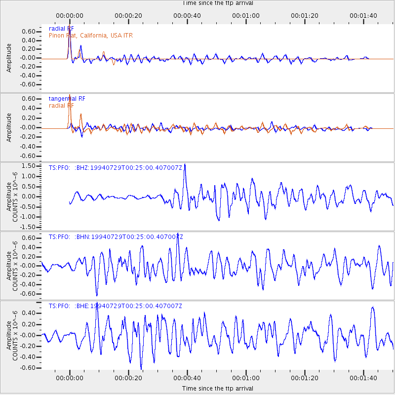
Earthquake location: Fox Islands, Aleutian Islands
Earthquake latitude/longitude: 52.4/-168.3
Earthquake time(UTC): 1994/07/29 (210) 00:17:48 GMT
Earthquake Depth: 33 km
Earthquake Magnitude: 5.9 MB, 5.6 MS, 5.8 UNKNOWN, 5.6 ML
Earthquake Catalog/Contributor: WHDF/NEIC
Network: TS TERRAscope (Southern California Seismic Network)
Station: PFO Pinon Flat, California, USA
Lat/Lon: 33.61 N/116.46 W
Elevation: 1280 m
Distance: 41.3 deg
Az: 96.074 deg
Baz: 313.099 deg
Ray Param: 0.07381531
Estimated Moho Depth: 35.5 km
Estimated Crust Vp/Vs: 1.63
Assumed Crust Vp: 6.264 km/s
Estimated Crust Vs: 3.837 km/s
Estimated Crust Poisson's Ratio: 0.20
Radial Match: 83.90109 %
Radial Bump: 400
Transverse Match: 63.26776 %
Transverse Bump: 400
SOD ConfigId: 17000
Insert Time: 2010-02-26 14:42:46.615 +0000
GWidth: 2.5
Max Bumps: 400
Tol: 0.001

Signal To Noise

ChannelStoNSTALTA
TS:PFO: :BHN:19940729T00:25:00.407007Z1.2321929.5343694E-87.73773E-8
TS:PFO: :BHE:19940729T00:25:00.407007Z1.81046161.1564785E-76.387754E-8
TS:PFO: :BHZ:19940729T00:25:00.407007Z1.7240771.8306471E-71.0618128E-7
Arrivals
Ps3.8 SECOND
PpPs14 SECOND
PsPs/PpSs18 SECOND