You are here: Home > Network List > MN - MEDNET Project Stations List
> Station VTS Vitosha, Bulgary > Earthquake Result Viewer
VTS Vitosha, Bulgary - Earthquake Result Viewer
| Earthquake location: |
Hokkaido, Japan Region |
| Earthquake latitude/longitude: |
42.1/144.3 |
| Earthquake time(UTC): |
2004/11/11 (316) 10:02:47 GMT |
| Earthquake Depth: |
33 km |
| Earthquake Magnitude: |
5.9 MB, 6.0 MS, 6.1 MW, 6.1 MW |
| Earthquake Catalog/Contributor: |
WHDF/NEIC |
|
| Network: |
MN MEDNET Project |
| Station: |
VTS Vitosha, Bulgary |
| Lat/Lon: |
42.62 N/23.24 E |
| Elevation: |
1490 m |
|
| Distance: |
80.4 deg |
| Az: |
320.132 deg |
| Baz: |
40.233 deg |
| Ray Param: |
0.048279736 |
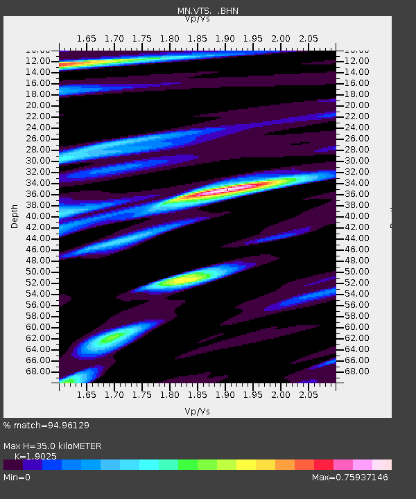
| Estimated Moho Depth: |
35.0 km |
| Estimated Crust Vp/Vs: |
1.90 |
| Assumed Crust Vp: |
6.291 km/s |
| Estimated Crust Vs: |
3.307 km/s |
| Estimated Crust Poisson's Ratio: |
0.31 |
|
| Radial Match: |
94.96129 % |
| Radial Bump: |
400 |
| Transverse Match: |
87.067444 % |
| Transverse Bump: |
400 |
| SOD ConfigId: |
2459 |
| Insert Time: |
2010-03-08 17:54:46.929 +0000 |
| GWidth: |
2.5 |
| Max Bumps: |
400 |
| Tol: |
0.001 |
|

Signal To Noise
| Channel | StoN | STA | LTA |
| MN:VTS: :BHN:20041111T10:14:24.254011Z | 7.275555 | 4.3344195E-7 | 5.9575108E-8 |
| MN:VTS: :BHE:20041111T10:14:24.254011Z | 5.81718 | 2.641357E-7 | 4.5406143E-8 |
| MN:VTS: :BHZ:20041111T10:14:24.254011Z | 23.947533 | 1.4069974E-6 | 5.8753336E-8 |
| Arrivals |
| Ps | 5.1 SECOND |
| PpPs | 16 SECOND |
| PsPs/PpSs | 21 SECOND |


