You are here: Home > Network List > AV - Alaska Volcano Observatory Stations List
> Station SPCR Ckakachatna River, Mount Spurr, Alaska > Earthquake Result Viewer
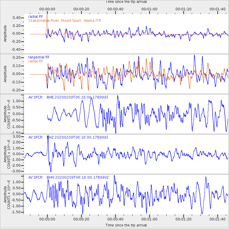
SPCR Ckakachatna River, Mount Spurr, Alaska - Earthquake Result Viewer
*The percent match for this event was below the threshold and hence no stack was calculated.
| Earthquake location: |
New Britain Region, P.N.G. |
| Earthquake latitude/longitude: |
-5.5/152.1 |
| Earthquake time(UTC): |
2020/02/09 (040) 06:04:29 GMT |
| Earthquake Depth: |
31 km |
| Earthquake Magnitude: |
6.2 mww |
| Earthquake Catalog/Contributor: |
NEIC PDE/us |
|
| Network: |
AV Alaska Volcano Observatory |
| Station: |
SPCR Ckakachatna River, Mount Spurr, Alaska |
| Lat/Lon: |
61.20 N/152.21 W |
| Elevation: |
984 m |
|
| Distance: |
79.1 deg |
| Az: |
24.038 deg |
| Baz: |
236.873 deg |
| Ray Param: |
$rayparam |
*The percent match for this event was below the threshold and hence was not used in the summary stack. |
|
| Radial Match: |
54.588917 % |
| Radial Bump: |
400 |
| Transverse Match: |
54.04717 % |
| Transverse Bump: |
400 |
| SOD ConfigId: |
20792311 |
| Insert Time: |
2020-03-02 00:14:14.863 +0000 |
| GWidth: |
2.5 |
| Max Bumps: |
400 |
| Tol: |
0.001 |
|
Signal To Noise
| Channel | StoN | STA | LTA |
| AV:SPCR: :BHZ:20200209T06:16:00.178999Z | 4.1972857 | 1.6150768E-6 | 3.8479078E-7 |
| AV:SPCR: :BHN:20200209T06:16:00.178999Z | 1.2652521 | 6.563502E-7 | 5.1875054E-7 |
| AV:SPCR: :BHE:20200209T06:16:00.178999Z | 1.5889381 | 6.8215166E-7 | 4.2931293E-7 |
| Arrivals |
| Ps | |
| PpPs | |
| PsPs/PpSs | |


