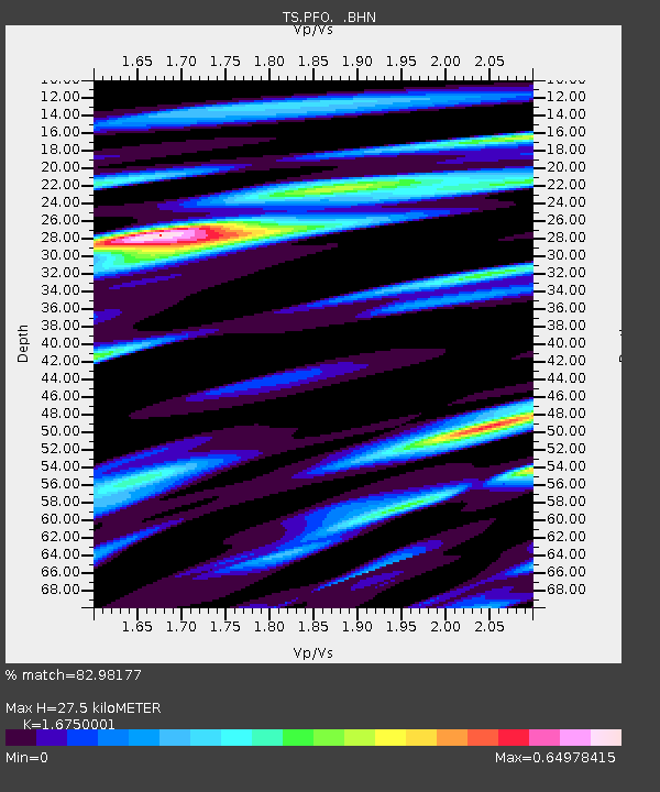
PFO Pinon Flat, California, USA - Earthquake Result Viewer
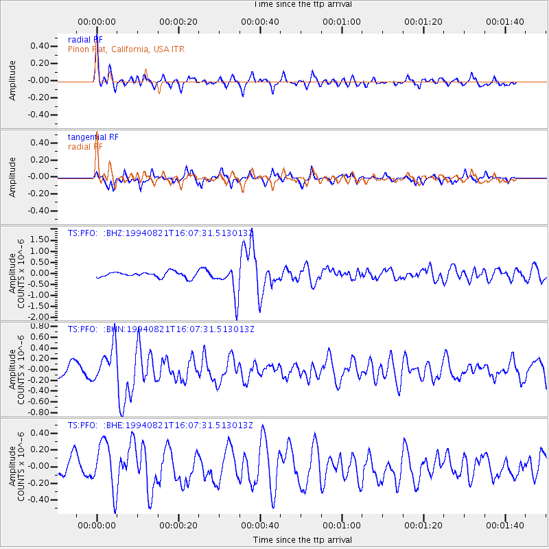
Earthquake location: East Of Lake Baykal, Russia
Earthquake latitude/longitude: 56.7/117.8
Earthquake time(UTC): 1994/08/21 (233) 15:56:01 GMT
Earthquake Depth: 33 km
Earthquake Magnitude: 5.7 MB, 5.8 MS, 6.0 UNKNOWN, 6.0 MW
Earthquake Catalog/Contributor: WHDF/NEIC
Network: TS TERRAscope (Southern California Seismic Network)
Station: PFO Pinon Flat, California, USA
Lat/Lon: 33.61 N/116.46 W
Elevation: 1280 m
Distance: 79.0 deg
Az: 43.639 deg
Baz: 332.829 deg
Ray Param: 0.04919224
Estimated Moho Depth: 27.5 km
Estimated Crust Vp/Vs: 1.68
Assumed Crust Vp: 6.264 km/s
Estimated Crust Vs: 3.739 km/s
Estimated Crust Poisson's Ratio: 0.22
Radial Match: 82.98177 %
Radial Bump: 400
Transverse Match: 56.716274 %
Transverse Bump: 378
SOD ConfigId: 17000
Insert Time: 2010-02-26 14:42:48.835 +0000
GWidth: 2.5
Max Bumps: 400
Tol: 0.001

Signal To Noise

ChannelStoNSTALTA
TS:PFO: :BHN:19940821T16:07:31.513013Z3.22414353.376367E-71.04721366E-7
TS:PFO: :BHE:19940821T16:07:31.513013Z2.67952163.0591346E-71.1416719E-7
TS:PFO: :BHZ:19940821T16:07:31.513013Z5.87615737.3154047E-71.24493E-7
Arrivals
Ps3.1 SECOND
PpPs11 SECOND
PsPs/PpSs14 SECOND