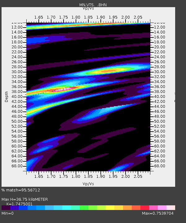
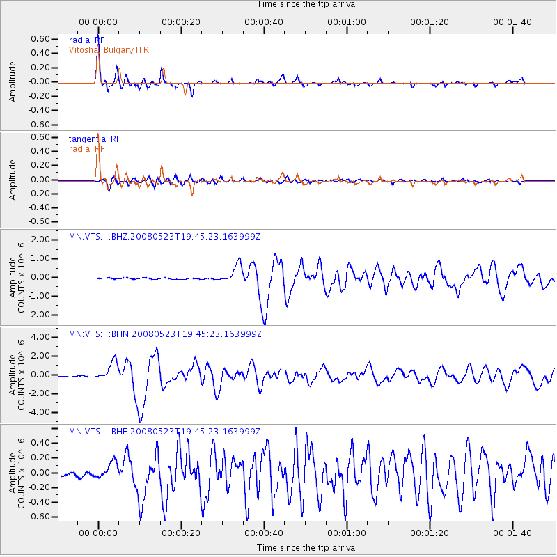
VTS Vitosha, Bulgary - Earthquake Result Viewer

Earthquake location: Central Mid-Atlantic Ridge
Earthquake latitude/longitude: 7.3/-34.9
Earthquake time(UTC): 2008/05/23 (144) 19:35:34 GMT
Earthquake Depth: 9.0 km
Earthquake Magnitude: 6.0 MB, 6.4 MS, 6.5 MW, 6.5 MW
Earthquake Catalog/Contributor: WHDF/NEIC
Network: MN MEDNET Project
Station: VTS Vitosha, Bulgary
Lat/Lon: 42.62 N/23.24 E
Elevation: 1490 m
Distance: 61.8 deg
Az: 45.319 deg
Baz: 252.849 deg
Ray Param: 0.06061891
Estimated Moho Depth: 36.75 km
Estimated Crust Vp/Vs: 1.75
Assumed Crust Vp: 6.291 km/s
Estimated Crust Vs: 3.6 km/s
Estimated Crust Poisson's Ratio: 0.26
Radial Match: 95.56712 %
Radial Bump: 360
Transverse Match: 84.39679 %
Transverse Bump: 400
SOD ConfigId: 2504
Insert Time: 2010-03-08 17:55:26.946 +0000
GWidth: 2.5
Max Bumps: 400
Tol: 0.001

Signal To Noise

ChannelStoNSTALTA
MN:VTS: :BHN:20080523T19:45:23.163999Z16.402511.0276457E-66.2651736E-8
MN:VTS: :BHE:20080523T19:45:23.163999Z3.99923631.13815425E-72.8459288E-8
MN:VTS: :BHZ:20080523T19:45:23.163999Z15.868235.0317266E-73.1709437E-8
Arrivals
Ps4.6 SECOND
PpPs15 SECOND
PsPs/PpSs20 SECOND