You are here: Home > Network List > TA - USArray Transportable Network (new EarthScope stations) Stations List
> Station D25K Kavik River, AK, USA > Earthquake Result Viewer
D25K Kavik River, AK, USA - Earthquake Result Viewer
| Earthquake location: |
New Britain Region, P.N.G. |
| Earthquake latitude/longitude: |
-5.5/152.1 |
| Earthquake time(UTC): |
2020/02/09 (040) 06:04:29 GMT |
| Earthquake Depth: |
31 km |
| Earthquake Magnitude: |
6.2 mww |
| Earthquake Catalog/Contributor: |
NEIC PDE/us |
|
| Network: |
TA USArray Transportable Network (new EarthScope stations) |
| Station: |
D25K Kavik River, AK, USA |
| Lat/Lon: |
69.32 N/146.38 W |
| Elevation: |
770 m |
|
| Distance: |
85.4 deg |
| Az: |
18.255 deg |
| Baz: |
241.397 deg |
| Ray Param: |
0.044760928 |
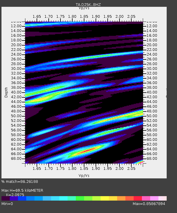
| Estimated Moho Depth: |
69.5 km |
| Estimated Crust Vp/Vs: |
2.10 |
| Assumed Crust Vp: |
6.378 km/s |
| Estimated Crust Vs: |
3.041 km/s |
| Estimated Crust Poisson's Ratio: |
0.35 |
|
| Radial Match: |
86.26188 % |
| Radial Bump: |
400 |
| Transverse Match: |
79.590706 % |
| Transverse Bump: |
400 |
| SOD ConfigId: |
20792311 |
| Insert Time: |
2020-03-02 02:18:59.091 +0000 |
| GWidth: |
2.5 |
| Max Bumps: |
400 |
| Tol: |
0.001 |
|
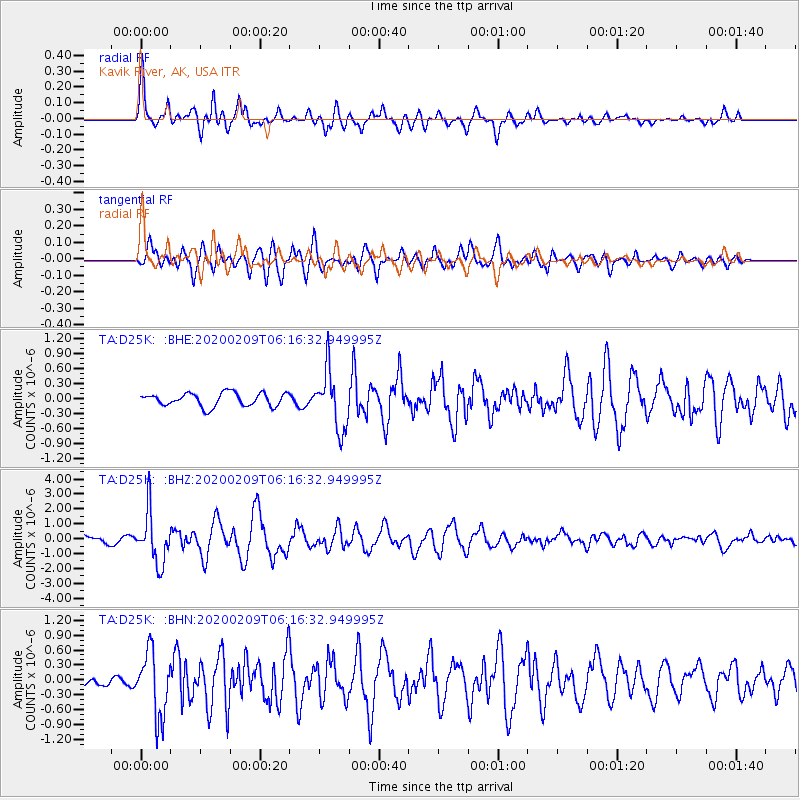
Signal To Noise
| Channel | StoN | STA | LTA |
| TA:D25K: :BHZ:20200209T06:16:32.949995Z | 8.6912775 | 1.7100041E-6 | 1.9674947E-7 |
| TA:D25K: :BHN:20200209T06:16:32.949995Z | 5.054795 | 6.4292277E-7 | 1.2719069E-7 |
| TA:D25K: :BHE:20200209T06:16:32.949995Z | 4.4103756 | 5.842099E-7 | 1.324626E-7 |
| Arrivals |
| Ps | 12 SECOND |
| PpPs | 33 SECOND |
| PsPs/PpSs | 45 SECOND |


