You are here: Home > Network List > TA - USArray Transportable Network (new EarthScope stations) Stations List
> Station E18K Tukpahlearik Creek, AK, USA > Earthquake Result Viewer
E18K Tukpahlearik Creek, AK, USA - Earthquake Result Viewer
| Earthquake location: |
New Britain Region, P.N.G. |
| Earthquake latitude/longitude: |
-5.5/152.1 |
| Earthquake time(UTC): |
2020/02/09 (040) 06:04:29 GMT |
| Earthquake Depth: |
31 km |
| Earthquake Magnitude: |
6.2 mww |
| Earthquake Catalog/Contributor: |
NEIC PDE/us |
|
| Network: |
TA USArray Transportable Network (new EarthScope stations) |
| Station: |
E18K Tukpahlearik Creek, AK, USA |
| Lat/Lon: |
67.42 N/160.60 W |
| Elevation: |
297 m |
|
| Distance: |
80.0 deg |
| Az: |
16.748 deg |
| Baz: |
227.98 deg |
| Ray Param: |
0.048542477 |
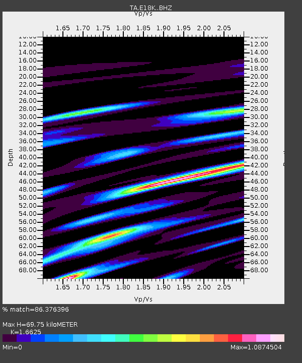
| Estimated Moho Depth: |
69.75 km |
| Estimated Crust Vp/Vs: |
1.66 |
| Assumed Crust Vp: |
6.276 km/s |
| Estimated Crust Vs: |
3.775 km/s |
| Estimated Crust Poisson's Ratio: |
0.22 |
|
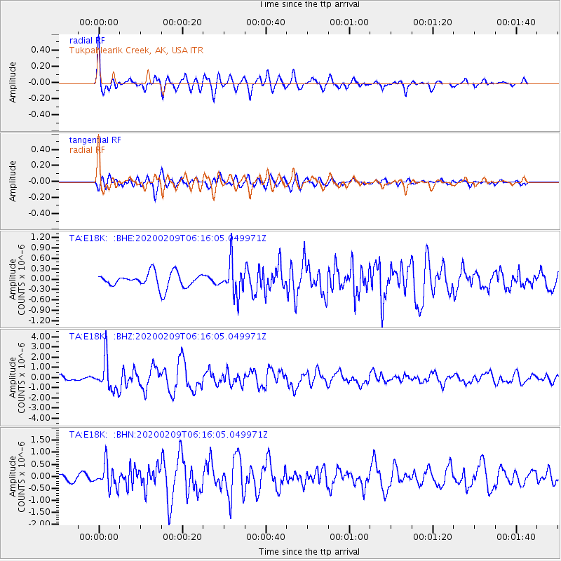
| Radial Match: |
86.376396 % |
| Radial Bump: |
400 |
| Transverse Match: |
74.4488 % |
| Transverse Bump: |
400 |
| SOD ConfigId: |
20792311 |
| Insert Time: |
2020-03-02 02:19:17.875 +0000 |
| GWidth: |
2.5 |
| Max Bumps: |
400 |
| Tol: |
0.001 |
|
Signal To Noise
| Channel | StoN | STA | LTA |
| TA:E18K: :BHZ:20200209T06:16:05.049971Z | 8.374827 | 1.5898399E-6 | 1.8983553E-7 |
| TA:E18K: :BHN:20200209T06:16:05.049971Z | 4.2328362 | 5.0278487E-7 | 1.1878203E-7 |
| TA:E18K: :BHE:20200209T06:16:05.049971Z | 2.3007805 | 4.859807E-7 | 2.1122428E-7 |
| Arrivals |
| Ps | 7.6 SECOND |
| PpPs | 29 SECOND |
| PsPs/PpSs | 36 SECOND |


