You are here: Home > Network List > TS - TERRAscope (Southern California Seismic Network) Stations List
> Station PFO Pinon Flat, California, USA > Earthquake Result Viewer
PFO Pinon Flat, California, USA - Earthquake Result Viewer
| Earthquake location: |
Northern Colombia |
| Earthquake latitude/longitude: |
7.1/-76.7 |
| Earthquake time(UTC): |
1994/09/13 (256) 10:01:34 GMT |
| Earthquake Depth: |
33 km |
| Earthquake Magnitude: |
5.8 MB, 5.6 MS |
| Earthquake Catalog/Contributor: |
WHDF/NEIC |
|
| Network: |
TS TERRAscope (Southern California Seismic Network) |
| Station: |
PFO Pinon Flat, California, USA |
| Lat/Lon: |
33.61 N/116.46 W |
| Elevation: |
1280 m |
|
| Distance: |
45.2 deg |
| Az: |
311.268 deg |
| Baz: |
116.636 deg |
| Ray Param: |
0.071352564 |
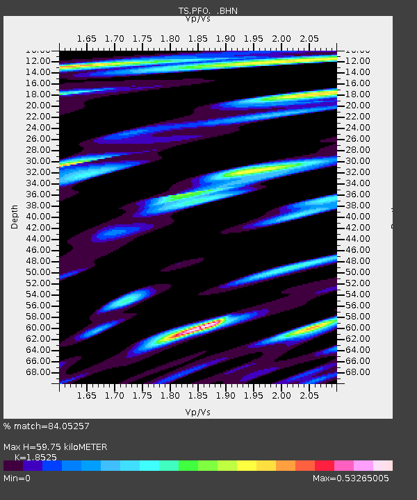
| Estimated Moho Depth: |
59.75 km |
| Estimated Crust Vp/Vs: |
1.85 |
| Assumed Crust Vp: |
6.264 km/s |
| Estimated Crust Vs: |
3.381 km/s |
| Estimated Crust Poisson's Ratio: |
0.29 |
|
| Radial Match: |
84.05257 % |
| Radial Bump: |
400 |
| Transverse Match: |
64.26647 % |
| Transverse Bump: |
400 |
| SOD ConfigId: |
17000 |
| Insert Time: |
2010-02-26 14:42:52.593 +0000 |
| GWidth: |
2.5 |
| Max Bumps: |
400 |
| Tol: |
0.001 |
|
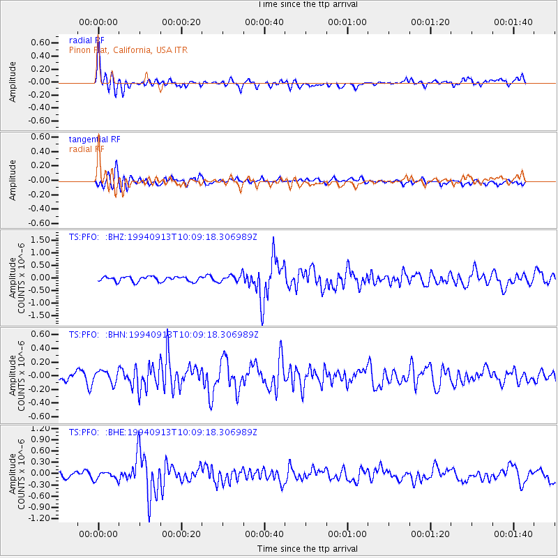
Signal To Noise
| Channel | StoN | STA | LTA |
| TS:PFO: :BHN:19940913T10:09:18.306989Z | 1.3739165 | 9.1497334E-8 | 6.6595994E-8 |
| TS:PFO: :BHE:19940913T10:09:18.306989Z | 0.9978316 | 9.671528E-8 | 9.6925454E-8 |
| TS:PFO: :BHZ:19940913T10:09:18.306989Z | 1.4968226 | 1.5119015E-7 | 1.010074E-7 |
| Arrivals |
| Ps | 8.6 SECOND |
| PpPs | 26 SECOND |
| PsPs/PpSs | 34 SECOND |


