You are here: Home > Network List > TA - USArray Transportable Network (new EarthScope stations) Stations List
> Station K15K Wolf Creek Mountain, AK, USA > Earthquake Result Viewer
K15K Wolf Creek Mountain, AK, USA - Earthquake Result Viewer

| Earthquake location: |
New Britain Region, P.N.G. |
| Earthquake latitude/longitude: |
-5.5/152.1 |
| Earthquake time(UTC): |
2020/02/09 (040) 06:04:29 GMT |
| Earthquake Depth: |
31 km |
| Earthquake Magnitude: |
6.2 mww |
| Earthquake Catalog/Contributor: |
NEIC PDE/us |
|
| Network: |
TA USArray Transportable Network (new EarthScope stations) |
| Station: |
K15K Wolf Creek Mountain, AK, USA |
| Lat/Lon: |
62.29 N/161.53 W |
| Elevation: |
346 m |
|
| Distance: |
76.3 deg |
| Az: |
20.382 deg |
| Baz: |
227.889 deg |
| Ray Param: |
0.051082876 |
| Estimated Moho Depth: |
31.0 km |
| Estimated Crust Vp/Vs: |
1.88 |
| Assumed Crust Vp: |
6.276 km/s |
| Estimated Crust Vs: |
3.329 km/s |
| Estimated Crust Poisson's Ratio: |
0.30 |
|
| Radial Match: |
81.59507 % |
| Radial Bump: |
400 |
| Transverse Match: |
65.8343 % |
| Transverse Bump: |
400 |
| SOD ConfigId: |
20792311 |
| Insert Time: |
2020-03-02 02:25:06.765 +0000 |
| GWidth: |
2.5 |
| Max Bumps: |
400 |
| Tol: |
0.001 |
|
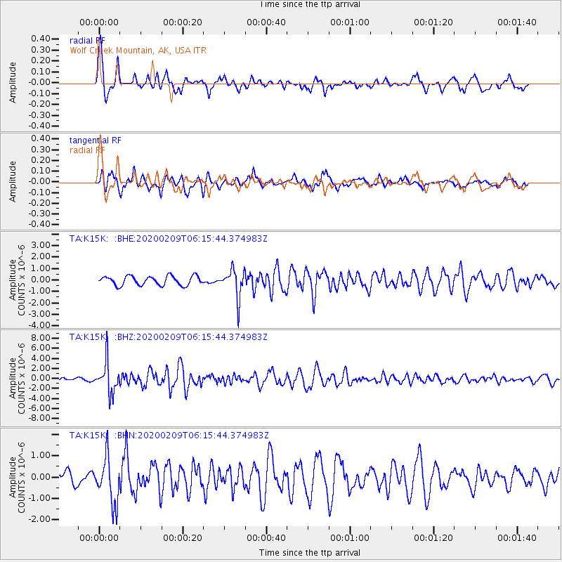
Signal To Noise
| Channel | StoN | STA | LTA |
| TA:K15K: :BHZ:20200209T06:15:44.374983Z | 8.047789 | 3.1964298E-6 | 3.9718114E-7 |
| TA:K15K: :BHN:20200209T06:15:44.374983Z | 2.770279 | 1.0935792E-6 | 3.9475418E-7 |
| TA:K15K: :BHE:20200209T06:15:44.374983Z | 3.177017 | 1.2609152E-6 | 3.968865E-7 |
| Arrivals |
| Ps | 4.5 SECOND |
| PpPs | 14 SECOND |
| PsPs/PpSs | 18 SECOND |


