You are here: Home > Network List > TA - USArray Transportable Network (new EarthScope stations) Stations List
> Station K29M Barlow Dome, YT, CAN > Earthquake Result Viewer
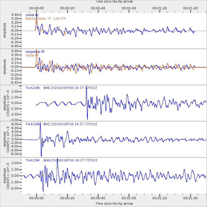
K29M Barlow Dome, YT, CAN - Earthquake Result Viewer

| Earthquake location: |
New Britain Region, P.N.G. |
| Earthquake latitude/longitude: |
-5.5/152.1 |
| Earthquake time(UTC): |
2020/02/09 (040) 06:04:29 GMT |
| Earthquake Depth: |
31 km |
| Earthquake Magnitude: |
6.2 mww |
| Earthquake Catalog/Contributor: |
NEIC PDE/us |
|
| Network: |
TA USArray Transportable Network (new EarthScope stations) |
| Station: |
K29M Barlow Dome, YT, CAN |
| Lat/Lon: |
63.84 N/137.52 W |
| Elevation: |
1367 m |
|
| Distance: |
86.4 deg |
| Az: |
24.729 deg |
| Baz: |
249.992 deg |
| Ray Param: |
0.044073146 |
| Estimated Moho Depth: |
63.25 km |
| Estimated Crust Vp/Vs: |
1.88 |
| Assumed Crust Vp: |
6.566 km/s |
| Estimated Crust Vs: |
3.497 km/s |
| Estimated Crust Poisson's Ratio: |
0.30 |
|
| Radial Match: |
85.04064 % |
| Radial Bump: |
400 |
| Transverse Match: |
79.94864 % |
| Transverse Bump: |
400 |
| SOD ConfigId: |
20792311 |
| Insert Time: |
2020-03-02 02:25:17.241 +0000 |
| GWidth: |
2.5 |
| Max Bumps: |
400 |
| Tol: |
0.001 |
|
Signal To Noise
| Channel | StoN | STA | LTA |
| TA:K29M: :BHZ:20200209T06:16:37.72502Z | 10.646789 | 3.443759E-6 | 3.234552E-7 |
| TA:K29M: :BHN:20200209T06:16:37.72502Z | 3.6511643 | 7.2842096E-7 | 1.9950375E-7 |
| TA:K29M: :BHE:20200209T06:16:37.72502Z | 4.9135528 | 1.0703762E-6 | 2.1784159E-7 |
| Arrivals |
| Ps | 8.6 SECOND |
| PpPs | 27 SECOND |
| PsPs/PpSs | 36 SECOND |


