You are here: Home > Network List > TS - TERRAscope (Southern California Seismic Network) Stations List
> Station PFO Pinon Flat, California, USA > Earthquake Result Viewer
PFO Pinon Flat, California, USA - Earthquake Result Viewer

| Earthquake location: |
Kuril Islands |
| Earthquake latitude/longitude: |
43.9/147.9 |
| Earthquake time(UTC): |
1994/10/09 (282) 07:55:38 GMT |
| Earthquake Depth: |
23 km |
| Earthquake Magnitude: |
6.5 MB, 7.0 MS, 6.7 UNKNOWN, 7.3 MW |
| Earthquake Catalog/Contributor: |
WHDF/NEIC |
|
| Network: |
TS TERRAscope (Southern California Seismic Network) |
| Station: |
PFO Pinon Flat, California, USA |
| Lat/Lon: |
33.61 N/116.46 W |
| Elevation: |
1280 m |
|
| Distance: |
71.3 deg |
| Az: |
61.287 deg |
| Baz: |
310.563 deg |
| Ray Param: |
0.05442545 |
| Estimated Moho Depth: |
30.5 km |
| Estimated Crust Vp/Vs: |
1.70 |
| Assumed Crust Vp: |
6.264 km/s |
| Estimated Crust Vs: |
3.695 km/s |
| Estimated Crust Poisson's Ratio: |
0.23 |
|
| Radial Match: |
96.69328 % |
| Radial Bump: |
329 |
| Transverse Match: |
91.070625 % |
| Transverse Bump: |
400 |
| SOD ConfigId: |
17000 |
| Insert Time: |
2010-02-26 14:42:53.695 +0000 |
| GWidth: |
2.5 |
| Max Bumps: |
400 |
| Tol: |
0.001 |
|
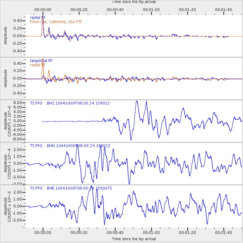
Signal To Noise
| Channel | StoN | STA | LTA |
| TS:PFO: :BHN:19941009T08:06:24.15802Z | 2.0603774 | 1.287229E-7 | 6.24754E-8 |
| TS:PFO: :BHE:19941009T08:06:24.158997Z | 1.6865587 | 2.555262E-7 | 1.5150744E-7 |
| TS:PFO: :BHZ:19941009T08:06:24.15802Z | 6.7942243 | 3.9856934E-7 | 5.8662966E-8 |
| Arrivals |
| Ps | 3.5 SECOND |
| PpPs | 13 SECOND |
| PsPs/PpSs | 16 SECOND |


