You are here: Home > Network List > TA - USArray Transportable Network (new EarthScope stations) Stations List
> Station R33M Jennings River, BC, CAN > Earthquake Result Viewer
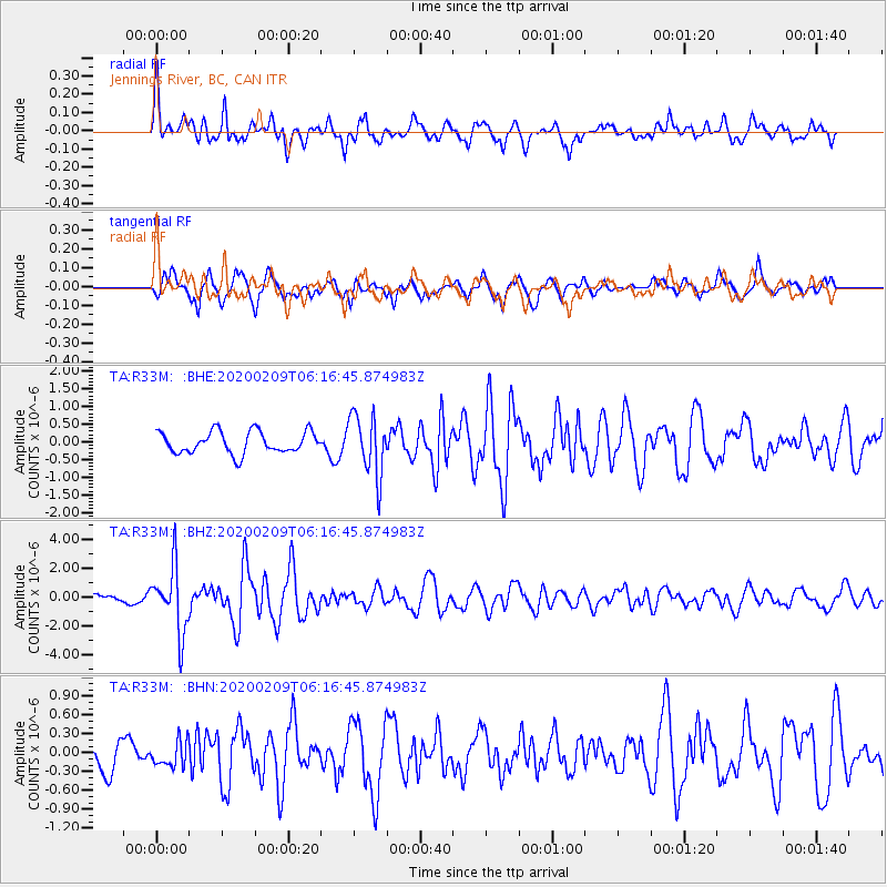
R33M Jennings River, BC, CAN - Earthquake Result Viewer
*The percent match for this event was below the threshold and hence no stack was calculated.
| Earthquake location: |
New Britain Region, P.N.G. |
| Earthquake latitude/longitude: |
-5.5/152.1 |
| Earthquake time(UTC): |
2020/02/09 (040) 06:04:29 GMT |
| Earthquake Depth: |
31 km |
| Earthquake Magnitude: |
6.2 mww |
| Earthquake Catalog/Contributor: |
NEIC PDE/us |
|
| Network: |
TA USArray Transportable Network (new EarthScope stations) |
| Station: |
R33M Jennings River, BC, CAN |
| Lat/Lon: |
59.39 N/130.97 W |
| Elevation: |
1437 m |
|
| Distance: |
88.0 deg |
| Az: |
29.914 deg |
| Baz: |
256.008 deg |
| Ray Param: |
$rayparam |
*The percent match for this event was below the threshold and hence was not used in the summary stack. |
|
| Radial Match: |
76.97581 % |
| Radial Bump: |
400 |
| Transverse Match: |
66.68408 % |
| Transverse Bump: |
400 |
| SOD ConfigId: |
20792311 |
| Insert Time: |
2020-03-02 02:30:24.100 +0000 |
| GWidth: |
2.5 |
| Max Bumps: |
400 |
| Tol: |
0.001 |
|
Signal To Noise
| Channel | StoN | STA | LTA |
| TA:R33M: :BHZ:20200209T06:16:45.874983Z | 9.33105 | 2.291078E-6 | 2.4553273E-7 |
| TA:R33M: :BHN:20200209T06:16:45.874983Z | 0.7073403 | 1.9585386E-7 | 2.7688773E-7 |
| TA:R33M: :BHE:20200209T06:16:45.874983Z | 2.7871578 | 8.5917634E-7 | 3.082625E-7 |
| Arrivals |
| Ps | |
| PpPs | |
| PsPs/PpSs | |


