You are here: Home > Network List > UW - Pacific Northwest Regional Seismic Network Stations List
> Station UMAT Pilot Rock, OR, USA > Earthquake Result Viewer
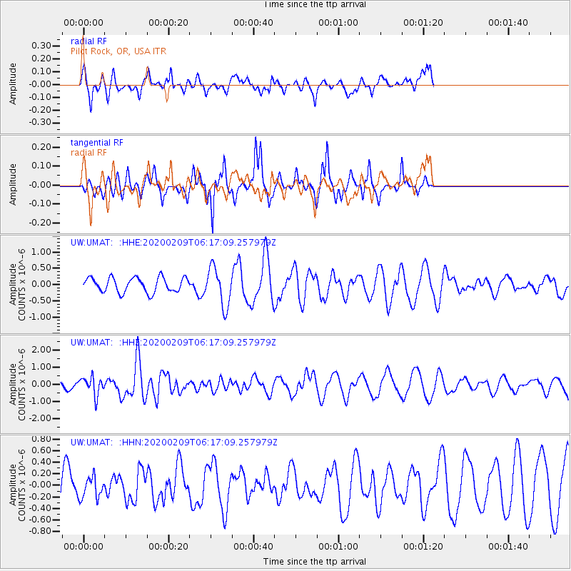
UMAT Pilot Rock, OR, USA - Earthquake Result Viewer
*The percent match for this event was below the threshold and hence no stack was calculated.
| Earthquake location: |
New Britain Region, P.N.G. |
| Earthquake latitude/longitude: |
-5.5/152.1 |
| Earthquake time(UTC): |
2020/02/09 (040) 06:04:29 GMT |
| Earthquake Depth: |
31 km |
| Earthquake Magnitude: |
6.2 mww |
| Earthquake Catalog/Contributor: |
NEIC PDE/us |
|
| Network: |
UW Pacific Northwest Regional Seismic Network |
| Station: |
UMAT Pilot Rock, OR, USA |
| Lat/Lon: |
45.29 N/118.96 W |
| Elevation: |
1318 m |
|
| Distance: |
93.1 deg |
| Az: |
44.975 deg |
| Baz: |
265.426 deg |
| Ray Param: |
$rayparam |
*The percent match for this event was below the threshold and hence was not used in the summary stack. |
|
| Radial Match: |
40.142212 % |
| Radial Bump: |
335 |
| Transverse Match: |
70.79932 % |
| Transverse Bump: |
276 |
| SOD ConfigId: |
20792311 |
| Insert Time: |
2020-03-02 02:50:37.071 +0000 |
| GWidth: |
2.5 |
| Max Bumps: |
400 |
| Tol: |
0.001 |
|
Signal To Noise
| Channel | StoN | STA | LTA |
| UW:UMAT: :HHZ:20200209T06:17:09.257979Z | 1.9848 | 5.3626263E-7 | 2.7018473E-7 |
| UW:UMAT: :HHN:20200209T06:17:09.257979Z | 0.51381105 | 1.7813373E-7 | 3.466911E-7 |
| UW:UMAT: :HHE:20200209T06:17:09.257979Z | 2.7170355 | 6.07018E-7 | 2.2341189E-7 |
| Arrivals |
| Ps | |
| PpPs | |
| PsPs/PpSs | |


