You are here: Home > Network List > TS - TERRAscope (Southern California Seismic Network) Stations List
> Station PFO Pinon Flat, California, USA > Earthquake Result Viewer
PFO Pinon Flat, California, USA - Earthquake Result Viewer
| Earthquake location: |
Kuril Islands |
| Earthquake latitude/longitude: |
45.7/149.2 |
| Earthquake time(UTC): |
1994/10/16 (289) 05:10:03 GMT |
| Earthquake Depth: |
139 km |
| Earthquake Magnitude: |
6.3 MB, 6.8 UNKNOWN, 6.7 MW |
| Earthquake Catalog/Contributor: |
WHDF/NEIC |
|
| Network: |
TS TERRAscope (Southern California Seismic Network) |
| Station: |
PFO Pinon Flat, California, USA |
| Lat/Lon: |
33.61 N/116.46 W |
| Elevation: |
1280 m |
|
| Distance: |
69.6 deg |
| Az: |
62.633 deg |
| Baz: |
311.82 deg |
| Ray Param: |
0.055193175 |
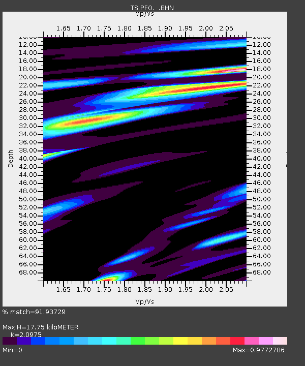
| Estimated Moho Depth: |
17.75 km |
| Estimated Crust Vp/Vs: |
2.10 |
| Assumed Crust Vp: |
6.264 km/s |
| Estimated Crust Vs: |
2.986 km/s |
| Estimated Crust Poisson's Ratio: |
0.35 |
|
| Radial Match: |
91.93729 % |
| Radial Bump: |
386 |
| Transverse Match: |
78.11367 % |
| Transverse Bump: |
400 |
| SOD ConfigId: |
17000 |
| Insert Time: |
2010-02-26 14:42:54.784 +0000 |
| GWidth: |
2.5 |
| Max Bumps: |
400 |
| Tol: |
0.001 |
|

Signal To Noise
| Channel | StoN | STA | LTA |
| TS:PFO: :BHN:19941016T05:20:26.287Z | 3.6708803 | 1.1111923E-6 | 3.027046E-7 |
| TS:PFO: :BHE:19941016T05:20:26.287Z | 4.8950057 | 1.1528941E-6 | 2.3552457E-7 |
| TS:PFO: :BHZ:19941016T05:20:26.287Z | 9.247296 | 3.2263056E-6 | 3.4889177E-7 |
| Arrivals |
| Ps | 3.2 SECOND |
| PpPs | 8.5 SECOND |
| PsPs/PpSs | 12 SECOND |


