You are here: Home > Network List > TA - USArray Transportable Network (new EarthScope stations) Stations List
> Station E18K Tukpahlearik Creek, AK, USA > Earthquake Result Viewer
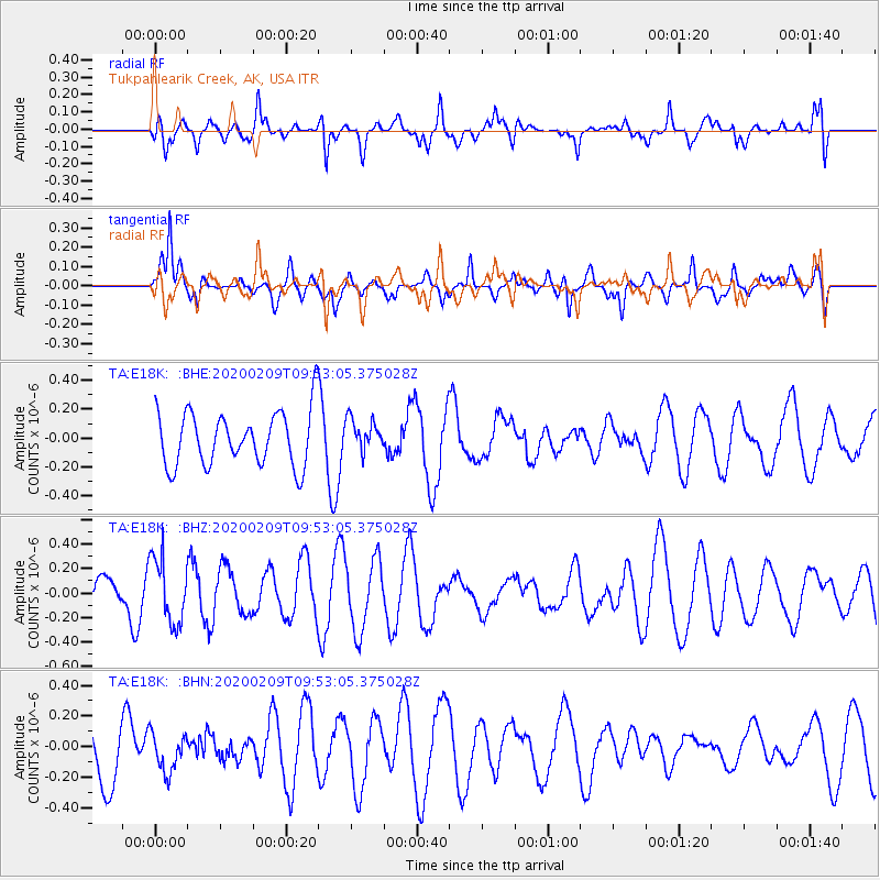
E18K Tukpahlearik Creek, AK, USA - Earthquake Result Viewer
*The percent match for this event was below the threshold and hence no stack was calculated.
| Earthquake location: |
Bismarck Sea |
| Earthquake latitude/longitude: |
-4.6/149.5 |
| Earthquake time(UTC): |
2020/02/09 (040) 09:42:24 GMT |
| Earthquake Depth: |
552 km |
| Earthquake Magnitude: |
5.5 Mww |
| Earthquake Catalog/Contributor: |
NEIC PDE/us |
|
| Network: |
TA USArray Transportable Network (new EarthScope stations) |
| Station: |
E18K Tukpahlearik Creek, AK, USA |
| Lat/Lon: |
67.42 N/160.60 W |
| Elevation: |
297 m |
|
| Distance: |
79.9 deg |
| Az: |
17.452 deg |
| Baz: |
230.734 deg |
| Ray Param: |
$rayparam |
*The percent match for this event was below the threshold and hence was not used in the summary stack. |
|
| Radial Match: |
36.973186 % |
| Radial Bump: |
400 |
| Transverse Match: |
49.867584 % |
| Transverse Bump: |
332 |
| SOD ConfigId: |
20792311 |
| Insert Time: |
2020-03-03 14:41:58.033 +0000 |
| GWidth: |
2.5 |
| Max Bumps: |
400 |
| Tol: |
0.001 |
|
Signal To Noise
| Channel | StoN | STA | LTA |
| TA:E18K: :BHZ:20200209T09:53:05.375028Z | 2.7591794 | 2.6890453E-7 | 9.745815E-8 |
| TA:E18K: :BHN:20200209T09:53:05.375028Z | 0.6713243 | 1.242677E-7 | 1.851083E-7 |
| TA:E18K: :BHE:20200209T09:53:05.375028Z | 0.6023557 | 1.13105735E-7 | 1.8777233E-7 |
| Arrivals |
| Ps | |
| PpPs | |
| PsPs/PpSs | |


