You are here: Home > Network List > G - GEOSCOPE Stations List
> Station CAN Canberra, Australia > Earthquake Result Viewer
CAN Canberra, Australia - Earthquake Result Viewer

| Earthquake location: |
Mindanao, Philippines |
| Earthquake latitude/longitude: |
5.5/125.1 |
| Earthquake time(UTC): |
2017/04/28 (118) 20:23:18 GMT |
| Earthquake Depth: |
10 km |
| Earthquake Magnitude: |
7.2 Mi |
| Earthquake Catalog/Contributor: |
NEIC PDE/pt |
|
| Network: |
G GEOSCOPE |
| Station: |
CAN Canberra, Australia |
| Lat/Lon: |
35.32 S/149.00 E |
| Elevation: |
650 m |
|
| Distance: |
46.4 deg |
| Az: |
152.733 deg |
| Baz: |
326.102 deg |
| Ray Param: |
0.07065897 |
| Estimated Moho Depth: |
25.5 km |
| Estimated Crust Vp/Vs: |
1.60 |
| Assumed Crust Vp: |
6.633 km/s |
| Estimated Crust Vs: |
4.146 km/s |
| Estimated Crust Poisson's Ratio: |
0.18 |
|
| Radial Match: |
96.02573 % |
| Radial Bump: |
310 |
| Transverse Match: |
88.60709 % |
| Transverse Bump: |
400 |
| SOD ConfigId: |
2028011 |
| Insert Time: |
2017-05-12 20:27:34.194 +0000 |
| GWidth: |
2.5 |
| Max Bumps: |
400 |
| Tol: |
0.001 |
|
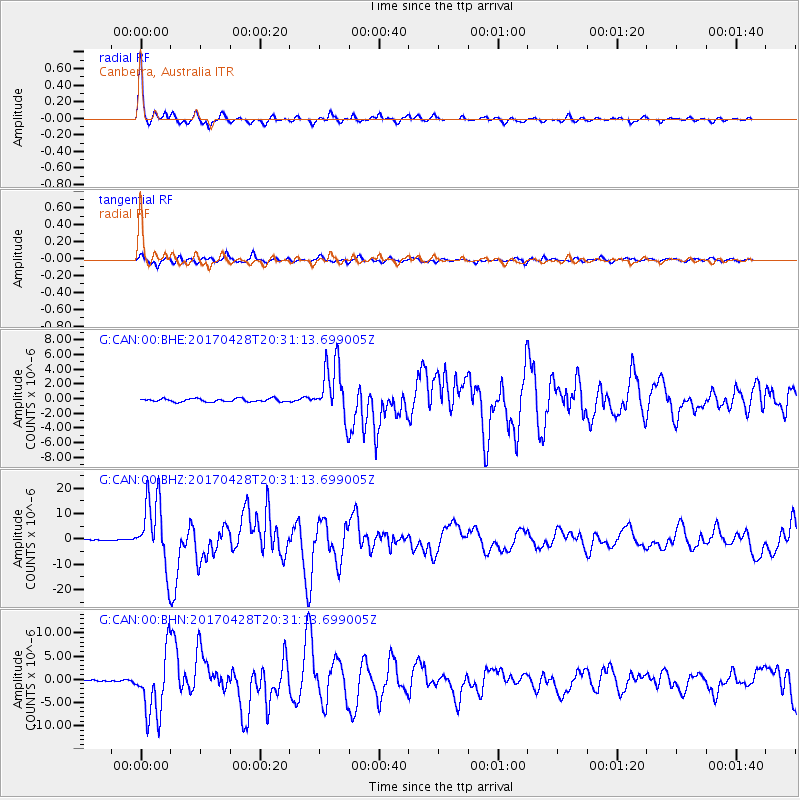
Signal To Noise
| Channel | StoN | STA | LTA |
| G:CAN:00:BHZ:20170428T20:31:13.699005Z | 27.635094 | 1.3500748E-5 | 4.8853633E-7 |
| G:CAN:00:BHN:20170428T20:31:13.699005Z | 31.055456 | 6.8130416E-6 | 2.1938307E-7 |
| G:CAN:00:BHE:20170428T20:31:13.699005Z | 17.735529 | 3.7872649E-6 | 2.1354113E-7 |
| Arrivals |
| Ps | 2.5 SECOND |
| PpPs | 9.3 SECOND |
| PsPs/PpSs | 12 SECOND |


