You are here: Home > Network List > AE - Arizona Broadband Seismic Network Stations List
> Station 113A Mohawk Valley, Roll, AZ, USA > Earthquake Result Viewer
113A Mohawk Valley, Roll, AZ, USA - Earthquake Result Viewer
| Earthquake location: |
Kuril Islands |
| Earthquake latitude/longitude: |
45.6/148.9 |
| Earthquake time(UTC): |
2020/02/13 (044) 10:33:44 GMT |
| Earthquake Depth: |
144 km |
| Earthquake Magnitude: |
7.0 mww |
| Earthquake Catalog/Contributor: |
NEIC PDE/us |
|
| Network: |
AE Arizona Broadband Seismic Network |
| Station: |
113A Mohawk Valley, Roll, AZ, USA |
| Lat/Lon: |
32.77 N/113.77 W |
| Elevation: |
118 m |
|
| Distance: |
72.0 deg |
| Az: |
61.471 deg |
| Baz: |
312.971 deg |
| Ray Param: |
0.05357435 |
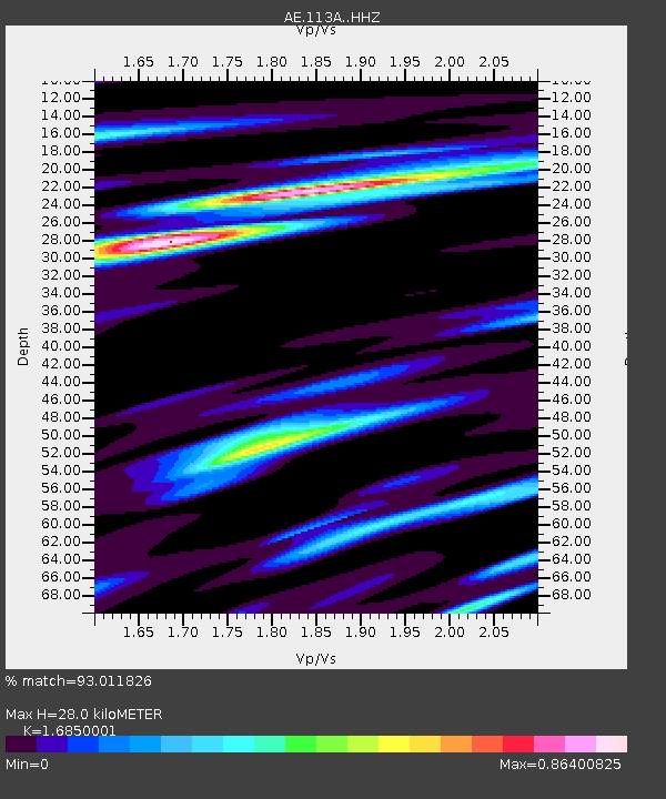
| Estimated Moho Depth: |
28.0 km |
| Estimated Crust Vp/Vs: |
1.69 |
| Assumed Crust Vp: |
6.264 km/s |
| Estimated Crust Vs: |
3.717 km/s |
| Estimated Crust Poisson's Ratio: |
0.23 |
|
| Radial Match: |
93.011826 % |
| Radial Bump: |
352 |
| Transverse Match: |
72.093636 % |
| Transverse Bump: |
400 |
| SOD ConfigId: |
20792311 |
| Insert Time: |
2020-03-05 11:01:32.457 +0000 |
| GWidth: |
2.5 |
| Max Bumps: |
400 |
| Tol: |
0.001 |
|

Signal To Noise
| Channel | StoN | STA | LTA |
| AE:113A: :HHZ:20200213T10:44:21.749019Z | 6.0151005 | 1.5554363E-6 | 2.5858859E-7 |
| AE:113A: :HHN:20200213T10:44:21.749019Z | 2.2656035 | 4.348283E-7 | 1.9192605E-7 |
| AE:113A: :HHE:20200213T10:44:21.749019Z | 2.0196338 | 5.357553E-7 | 2.6527348E-7 |
| Arrivals |
| Ps | 3.2 SECOND |
| PpPs | 12 SECOND |
| PsPs/PpSs | 15 SECOND |


