You are here: Home > Network List > AG - Arkansas Seismic Network Stations List
> Station U40A Yellville, AR > Earthquake Result Viewer
U40A Yellville, AR - Earthquake Result Viewer
| Earthquake location: |
Kuril Islands |
| Earthquake latitude/longitude: |
45.6/148.9 |
| Earthquake time(UTC): |
2020/02/13 (044) 10:33:44 GMT |
| Earthquake Depth: |
144 km |
| Earthquake Magnitude: |
7.0 mww |
| Earthquake Catalog/Contributor: |
NEIC PDE/us |
|
| Network: |
AG Arkansas Seismic Network |
| Station: |
U40A Yellville, AR |
| Lat/Lon: |
36.36 N/92.85 W |
| Elevation: |
374 m |
|
| Distance: |
81.2 deg |
| Az: |
46.034 deg |
| Baz: |
321.272 deg |
| Ray Param: |
0.04740614 |
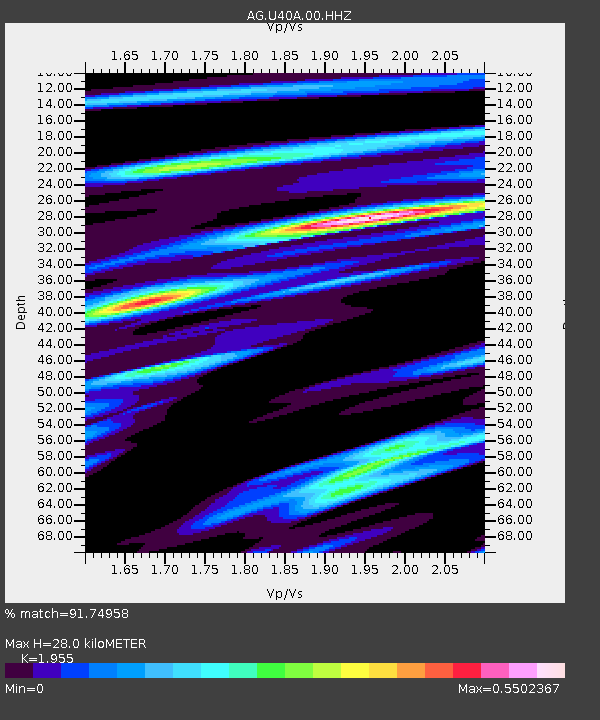
| Estimated Moho Depth: |
28.0 km |
| Estimated Crust Vp/Vs: |
1.96 |
| Assumed Crust Vp: |
6.53 km/s |
| Estimated Crust Vs: |
3.34 km/s |
| Estimated Crust Poisson's Ratio: |
0.32 |
|
| Radial Match: |
91.74958 % |
| Radial Bump: |
285 |
| Transverse Match: |
77.97643 % |
| Transverse Bump: |
299 |
| SOD ConfigId: |
20792311 |
| Insert Time: |
2020-03-05 11:06:04.826 +0000 |
| GWidth: |
2.5 |
| Max Bumps: |
400 |
| Tol: |
0.001 |
|

Signal To Noise
| Channel | StoN | STA | LTA |
| AG:U40A:00:HHZ:20200213T10:45:13.205013Z | 20.722366 | 5.375976E-6 | 2.5942867E-7 |
| AG:U40A:00:HHN:20200213T10:45:13.205013Z | 9.534647 | 2.055563E-6 | 2.1558878E-7 |
| AG:U40A:00:HHE:20200213T10:45:13.205013Z | 7.1687093 | 1.1633913E-6 | 1.6228742E-7 |
| Arrivals |
| Ps | 4.2 SECOND |
| PpPs | 12 SECOND |
| PsPs/PpSs | 17 SECOND |


