You are here: Home > Network List > AK - Alaska Regional Network Stations List
> Station COLD Coldfoot Broadband > Earthquake Result Viewer
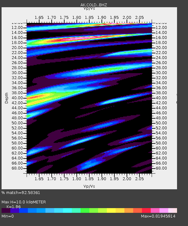
COLD Coldfoot Broadband - Earthquake Result Viewer
| Earthquake location: |
Kuril Islands |
| Earthquake latitude/longitude: |
45.6/148.9 |
| Earthquake time(UTC): |
2020/02/13 (044) 10:33:44 GMT |
| Earthquake Depth: |
144 km |
| Earthquake Magnitude: |
7.0 mww |
| Earthquake Catalog/Contributor: |
NEIC PDE/us |
|
| Network: |
AK Alaska Regional Network |
| Station: |
COLD Coldfoot Broadband |
| Lat/Lon: |
67.23 N/150.20 W |
| Elevation: |
377 m |
|
| Distance: |
37.9 deg |
| Az: |
33.627 deg |
| Baz: |
266.521 deg |
| Ray Param: |
0.07539217 |
| Estimated Moho Depth: |
10.0 km |
| Estimated Crust Vp/Vs: |
1.96 |
| Assumed Crust Vp: |
6.577 km/s |
| Estimated Crust Vs: |
3.355 km/s |
| Estimated Crust Poisson's Ratio: |
0.32 |
|
| Radial Match: |
92.58361 % |
| Radial Bump: |
376 |
| Transverse Match: |
83.27448 % |
| Transverse Bump: |
400 |
| SOD ConfigId: |
20792311 |
| Insert Time: |
2020-03-05 11:10:21.908 +0000 |
| GWidth: |
2.5 |
| Max Bumps: |
400 |
| Tol: |
0.001 |
|

Signal To Noise
| Channel | StoN | STA | LTA |
| AK:COLD: :BHZ:20200213T10:40:17.127986Z | 44.58428 | 8.660901E-6 | 1.9425906E-7 |
| AK:COLD: :BHN:20200213T10:40:17.127986Z | 7.8145404 | 1.3764401E-6 | 1.7613834E-7 |
| AK:COLD: :BHE:20200213T10:40:17.127986Z | 32.478226 | 5.001104E-6 | 1.539833E-7 |
| Arrivals |
| Ps | 1.6 SECOND |
| PpPs | 4.2 SECOND |
| PsPs/PpSs | 5.8 SECOND |


