You are here: Home > Network List > AK - Alaska Regional Network Stations List
> Station GRIN Grindle Hills, AK, USA > Earthquake Result Viewer
GRIN Grindle Hills, AK, USA - Earthquake Result Viewer
| Earthquake location: |
Kuril Islands |
| Earthquake latitude/longitude: |
45.6/148.9 |
| Earthquake time(UTC): |
2020/02/13 (044) 10:33:44 GMT |
| Earthquake Depth: |
144 km |
| Earthquake Magnitude: |
7.0 mww |
| Earthquake Catalog/Contributor: |
NEIC PDE/us |
|
| Network: |
AK Alaska Regional Network |
| Station: |
GRIN Grindle Hills, AK, USA |
| Lat/Lon: |
60.28 N/143.32 W |
| Elevation: |
625 m |
|
| Distance: |
41.4 deg |
| Az: |
44.218 deg |
| Baz: |
280.866 deg |
| Ray Param: |
0.07328938 |
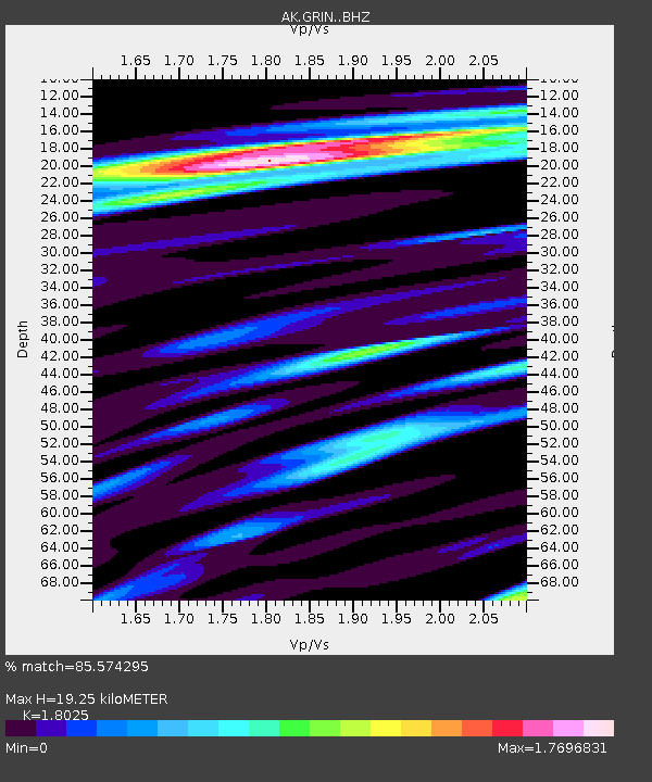
| Estimated Moho Depth: |
19.25 km |
| Estimated Crust Vp/Vs: |
1.80 |
| Assumed Crust Vp: |
6.566 km/s |
| Estimated Crust Vs: |
3.643 km/s |
| Estimated Crust Poisson's Ratio: |
0.28 |
|
| Radial Match: |
85.574295 % |
| Radial Bump: |
350 |
| Transverse Match: |
71.078224 % |
| Transverse Bump: |
400 |
| SOD ConfigId: |
20792311 |
| Insert Time: |
2020-03-05 11:13:25.699 +0000 |
| GWidth: |
2.5 |
| Max Bumps: |
400 |
| Tol: |
0.001 |
|

Signal To Noise
| Channel | StoN | STA | LTA |
| AK:GRIN: :BHZ:20200213T10:40:46.167995Z | 3.770812 | 4.182871E-6 | 1.109276E-6 |
| AK:GRIN: :BHN:20200213T10:40:46.167995Z | 2.0969555 | 2.6608539E-6 | 1.2689128E-6 |
| AK:GRIN: :BHE:20200213T10:40:46.167995Z | 1.0980924 | 2.0445357E-6 | 1.8618978E-6 |
| Arrivals |
| Ps | 2.5 SECOND |
| PpPs | 7.7 SECOND |
| PsPs/PpSs | 10 SECOND |


