You are here: Home > Network List > MN - MEDNET Project Stations List
> Station VTS Vitosha, Bulgary > Earthquake Result Viewer
VTS Vitosha, Bulgary - Earthquake Result Viewer
| Earthquake location: |
North Atlantic Ocean |
| Earthquake latitude/longitude: |
52.7/-33.7 |
| Earthquake time(UTC): |
1998/02/16 (047) 23:53:19 GMT |
| Earthquake Depth: |
10 km |
| Earthquake Magnitude: |
6.1 MB, 6.6 MS, 6.8 UNKNOWN, 6.8 ME |
| Earthquake Catalog/Contributor: |
WHDF/NEIC |
|
| Network: |
MN MEDNET Project |
| Station: |
VTS Vitosha, Bulgary |
| Lat/Lon: |
42.62 N/23.24 E |
| Elevation: |
1490 m |
|
| Distance: |
38.7 deg |
| Az: |
81.67 deg |
| Baz: |
305.372 deg |
| Ray Param: |
0.07541924 |
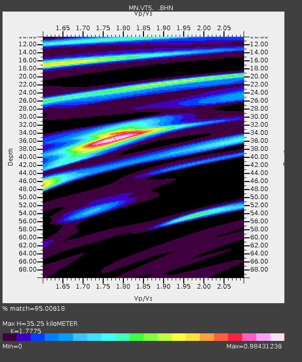
| Estimated Moho Depth: |
35.25 km |
| Estimated Crust Vp/Vs: |
1.78 |
| Assumed Crust Vp: |
6.291 km/s |
| Estimated Crust Vs: |
3.539 km/s |
| Estimated Crust Poisson's Ratio: |
0.27 |
|
| Radial Match: |
95.00618 % |
| Radial Bump: |
312 |
| Transverse Match: |
78.44853 % |
| Transverse Bump: |
400 |
| SOD ConfigId: |
6273 |
| Insert Time: |
2010-03-08 17:56:41.586 +0000 |
| GWidth: |
2.5 |
| Max Bumps: |
400 |
| Tol: |
0.001 |
|

Signal To Noise
| Channel | StoN | STA | LTA |
| MN:VTS: :BHN:19980217T00:00:12.689014Z | 6.3962965 | 3.8888163E-7 | 6.079794E-8 |
| MN:VTS: :BHE:19980217T00:00:12.689014Z | 8.949245 | 6.8851284E-7 | 7.6935294E-8 |
| MN:VTS: :BHZ:19980217T00:00:12.689014Z | 23.37896 | 1.3162418E-6 | 5.630027E-8 |
| Arrivals |
| Ps | 4.7 SECOND |
| PpPs | 15 SECOND |
| PsPs/PpSs | 19 SECOND |


