You are here: Home > Network List > TS - TERRAscope (Southern California Seismic Network) Stations List
> Station PFO Pinon Flat, California, USA > Earthquake Result Viewer
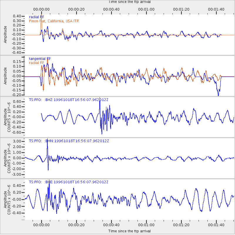
PFO Pinon Flat, California, USA - Earthquake Result Viewer
*The percent match for this event was below the threshold and hence no stack was calculated.
| Earthquake location: |
Near S. Coast Of Honshu, Japan |
| Earthquake latitude/longitude: |
33.7/137.4 |
| Earthquake time(UTC): |
1996/10/18 (292) 16:44:47 GMT |
| Earthquake Depth: |
338 km |
| Earthquake Magnitude: |
5.6 UNKNOWN, 5.4 MB, 5.6 MW |
| Earthquake Catalog/Contributor: |
WHDF/NEIC |
|
| Network: |
TS TERRAscope (Southern California Seismic Network) |
| Station: |
PFO Pinon Flat, California, USA |
| Lat/Lon: |
33.61 N/116.46 W |
| Elevation: |
1280 m |
|
| Distance: |
83.6 deg |
| Az: |
53.765 deg |
| Baz: |
306.303 deg |
| Ray Param: |
$rayparam |
*The percent match for this event was below the threshold and hence was not used in the summary stack. |
|
| Radial Match: |
51.294113 % |
| Radial Bump: |
400 |
| Transverse Match: |
57.811367 % |
| Transverse Bump: |
400 |
| SOD ConfigId: |
4480 |
| Insert Time: |
2010-02-26 14:43:00.841 +0000 |
| GWidth: |
2.5 |
| Max Bumps: |
400 |
| Tol: |
0.001 |
|
Signal To Noise
| Channel | StoN | STA | LTA |
| TS:PFO: :BHN:19961018T16:56:07.962012Z | 5.207292 | 9.545937E-7 | 1.8331865E-7 |
| TS:PFO: :BHE:19961018T16:56:07.962012Z | 2.0833137 | 2.2185147E-7 | 1.06489715E-7 |
| TS:PFO: :BHZ:19961018T16:56:07.962012Z | 2.0598392 | 2.6441077E-7 | 1.2836476E-7 |
| Arrivals |
| Ps | |
| PpPs | |
| PsPs/PpSs | |


