You are here: Home > Network List > AK - Alaska Regional Network Stations List
> Station MDM Murphy Dome > Earthquake Result Viewer
MDM Murphy Dome - Earthquake Result Viewer
| Earthquake location: |
Kuril Islands |
| Earthquake latitude/longitude: |
45.6/148.9 |
| Earthquake time(UTC): |
2020/02/13 (044) 10:33:44 GMT |
| Earthquake Depth: |
144 km |
| Earthquake Magnitude: |
7.0 mww |
| Earthquake Catalog/Contributor: |
NEIC PDE/us |
|
| Network: |
AK Alaska Regional Network |
| Station: |
MDM Murphy Dome |
| Lat/Lon: |
64.96 N/148.23 W |
| Elevation: |
634 m |
|
| Distance: |
38.6 deg |
| Az: |
37.331 deg |
| Baz: |
271.232 deg |
| Ray Param: |
0.07493688 |
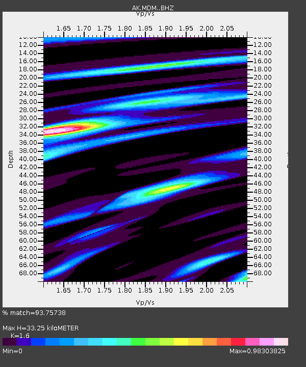
| Estimated Moho Depth: |
33.25 km |
| Estimated Crust Vp/Vs: |
1.60 |
| Assumed Crust Vp: |
6.566 km/s |
| Estimated Crust Vs: |
4.104 km/s |
| Estimated Crust Poisson's Ratio: |
0.18 |
|
| Radial Match: |
93.75738 % |
| Radial Bump: |
245 |
| Transverse Match: |
81.49357 % |
| Transverse Bump: |
322 |
| SOD ConfigId: |
20792311 |
| Insert Time: |
2020-03-05 11:25:45.085 +0000 |
| GWidth: |
2.5 |
| Max Bumps: |
400 |
| Tol: |
0.001 |
|
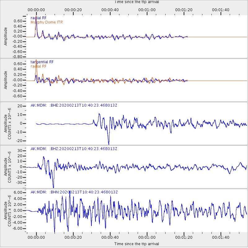
Signal To Noise
| Channel | StoN | STA | LTA |
| AK:MDM: :BHZ:20200213T10:40:23.468013Z | 28.761515 | 7.4922864E-6 | 2.6049693E-7 |
| AK:MDM: :BHN:20200213T10:40:23.468013Z | 2.4118576 | 7.5723057E-7 | 3.1396155E-7 |
| AK:MDM: :BHE:20200213T10:40:23.468013Z | 16.676495 | 4.6390755E-6 | 2.7818052E-7 |
| Arrivals |
| Ps | 3.3 SECOND |
| PpPs | 12 SECOND |
| PsPs/PpSs | 15 SECOND |


