You are here: Home > Network List > AU - Australian Seismological Centre Stations List
> Station MOO Moorlands, Tasmania > Earthquake Result Viewer
MOO Moorlands, Tasmania - Earthquake Result Viewer
| Earthquake location: |
Kuril Islands |
| Earthquake latitude/longitude: |
45.6/148.9 |
| Earthquake time(UTC): |
2020/02/13 (044) 10:33:44 GMT |
| Earthquake Depth: |
144 km |
| Earthquake Magnitude: |
7.0 mww |
| Earthquake Catalog/Contributor: |
NEIC PDE/us |
|
| Network: |
AU Australian Seismological Centre |
| Station: |
MOO Moorlands, Tasmania |
| Lat/Lon: |
42.44 S/147.19 E |
| Elevation: |
325 m |
|
| Distance: |
87.7 deg |
| Az: |
181.288 deg |
| Baz: |
1.221 deg |
| Ray Param: |
0.042813454 |
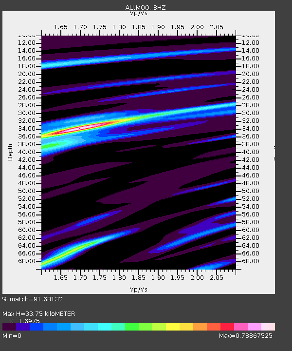
| Estimated Moho Depth: |
33.75 km |
| Estimated Crust Vp/Vs: |
1.70 |
| Assumed Crust Vp: |
6.477 km/s |
| Estimated Crust Vs: |
3.815 km/s |
| Estimated Crust Poisson's Ratio: |
0.23 |
|
| Radial Match: |
91.68132 % |
| Radial Bump: |
307 |
| Transverse Match: |
82.396225 % |
| Transverse Bump: |
400 |
| SOD ConfigId: |
20792311 |
| Insert Time: |
2020-03-05 11:36:24.650 +0000 |
| GWidth: |
2.5 |
| Max Bumps: |
400 |
| Tol: |
0.001 |
|

Signal To Noise
| Channel | StoN | STA | LTA |
| AU:MOO: :BHZ:20200213T10:45:45.694026Z | 7.993002 | 6.5981944E-6 | 8.2549644E-7 |
| AU:MOO: :BHN:20200213T10:45:45.694026Z | 4.480949 | 2.602767E-6 | 5.808517E-7 |
| AU:MOO: :BHE:20200213T10:45:45.694026Z | 0.7657563 | 4.2163006E-7 | 5.506061E-7 |
| Arrivals |
| Ps | 3.7 SECOND |
| PpPs | 14 SECOND |
| PsPs/PpSs | 17 SECOND |


