You are here: Home > Network List > II - Global Seismograph Network (GSN - IRIS/IDA) Stations List
> Station ABPO Ambohimpanompo, Madagascar > Earthquake Result Viewer
ABPO Ambohimpanompo, Madagascar - Earthquake Result Viewer
| Earthquake location: |
Mindanao, Philippines |
| Earthquake latitude/longitude: |
5.5/125.1 |
| Earthquake time(UTC): |
2017/04/28 (118) 20:23:18 GMT |
| Earthquake Depth: |
10 km |
| Earthquake Magnitude: |
7.2 Mi |
| Earthquake Catalog/Contributor: |
NEIC PDE/pt |
|
| Network: |
II Global Seismograph Network (GSN - IRIS/IDA) |
| Station: |
ABPO Ambohimpanompo, Madagascar |
| Lat/Lon: |
19.02 S/47.23 E |
| Elevation: |
1528 m |
|
| Distance: |
80.3 deg |
| Az: |
249.74 deg |
| Baz: |
80.794 deg |
| Ray Param: |
0.048345894 |
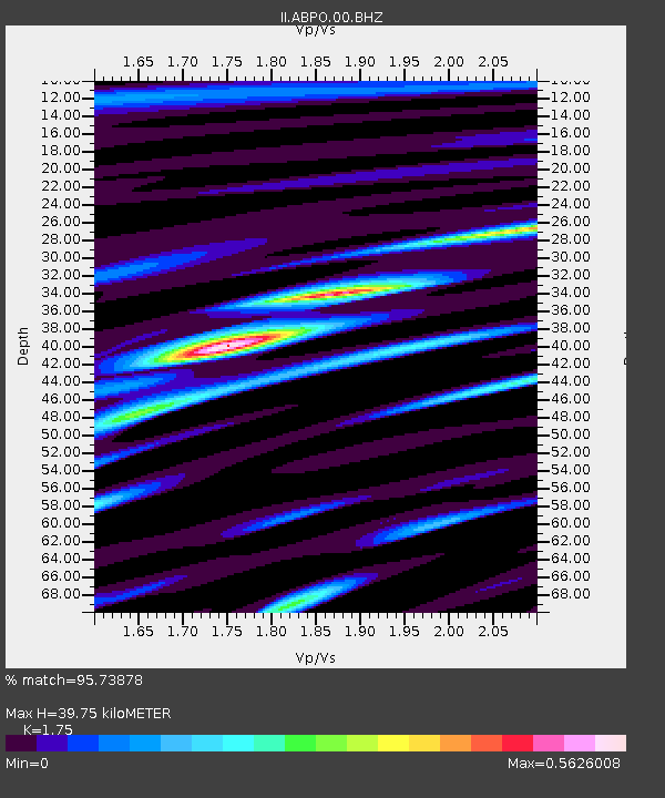
| Estimated Moho Depth: |
39.75 km |
| Estimated Crust Vp/Vs: |
1.75 |
| Assumed Crust Vp: |
6.642 km/s |
| Estimated Crust Vs: |
3.795 km/s |
| Estimated Crust Poisson's Ratio: |
0.26 |
|
| Radial Match: |
95.73878 % |
| Radial Bump: |
400 |
| Transverse Match: |
80.91544 % |
| Transverse Bump: |
400 |
| SOD ConfigId: |
2028011 |
| Insert Time: |
2017-05-12 20:28:15.291 +0000 |
| GWidth: |
2.5 |
| Max Bumps: |
400 |
| Tol: |
0.001 |
|

Signal To Noise
| Channel | StoN | STA | LTA |
| II:ABPO:00:BHZ:20170428T20:34:57.81897Z | 16.143677 | 8.865713E-6 | 5.491756E-7 |
| II:ABPO:00:BH1:20170428T20:34:57.81897Z | 1.714493 | 6.0319627E-7 | 3.5182197E-7 |
| II:ABPO:00:BH2:20170428T20:34:57.81897Z | 14.074143 | 3.254611E-6 | 2.3124755E-7 |
| Arrivals |
| Ps | 4.6 SECOND |
| PpPs | 16 SECOND |
| PsPs/PpSs | 21 SECOND |


