You are here: Home > Network List > AV - Alaska Volcano Observatory Stations List
> Station PLBL Mt. Peulik Volcano, Alaska > Earthquake Result Viewer
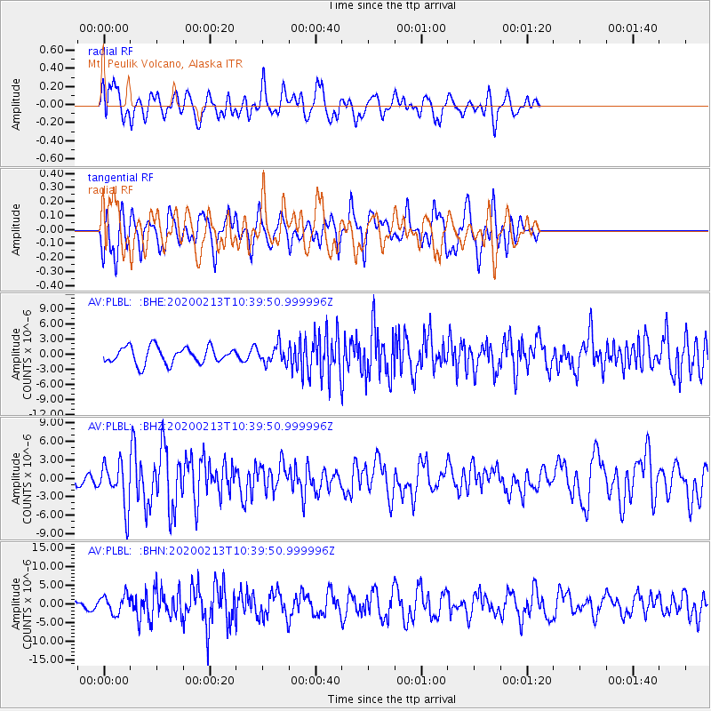
PLBL Mt. Peulik Volcano, Alaska - Earthquake Result Viewer
*The percent match for this event was below the threshold and hence no stack was calculated.
| Earthquake location: |
Kuril Islands |
| Earthquake latitude/longitude: |
45.6/148.9 |
| Earthquake time(UTC): |
2020/02/13 (044) 10:33:44 GMT |
| Earthquake Depth: |
144 km |
| Earthquake Magnitude: |
7.0 mww |
| Earthquake Catalog/Contributor: |
NEIC PDE/us |
|
| Network: |
AV Alaska Volcano Observatory |
| Station: |
PLBL Mt. Peulik Volcano, Alaska |
| Lat/Lon: |
57.70 N/156.82 W |
| Elevation: |
461 m |
|
| Distance: |
34.8 deg |
| Az: |
49.786 deg |
| Baz: |
273.689 deg |
| Ray Param: |
$rayparam |
*The percent match for this event was below the threshold and hence was not used in the summary stack. |
|
| Radial Match: |
62.102295 % |
| Radial Bump: |
400 |
| Transverse Match: |
71.07464 % |
| Transverse Bump: |
400 |
| SOD ConfigId: |
20792311 |
| Insert Time: |
2020-03-05 11:50:32.711 +0000 |
| GWidth: |
2.5 |
| Max Bumps: |
400 |
| Tol: |
0.001 |
|
Signal To Noise
| Channel | StoN | STA | LTA |
| AV:PLBL: :BHZ:20200213T10:39:50.999996Z | 3.4129229 | 3.6391536E-6 | 1.0662866E-6 |
| AV:PLBL: :BHN:20200213T10:39:50.999996Z | 2.2935522 | 2.4469903E-6 | 1.0668997E-6 |
| AV:PLBL: :BHE:20200213T10:39:50.999996Z | 1.1003706 | 1.8085713E-6 | 1.643602E-6 |
| Arrivals |
| Ps | |
| PpPs | |
| PsPs/PpSs | |


