You are here: Home > Network List > AV - Alaska Volcano Observatory Stations List
> Station SPCG Capps Glacier, Mount Spurr, Alaska > Earthquake Result Viewer
SPCG Capps Glacier, Mount Spurr, Alaska - Earthquake Result Viewer
| Earthquake location: |
Kuril Islands |
| Earthquake latitude/longitude: |
45.6/148.9 |
| Earthquake time(UTC): |
2020/02/13 (044) 10:33:44 GMT |
| Earthquake Depth: |
144 km |
| Earthquake Magnitude: |
7.0 mww |
| Earthquake Catalog/Contributor: |
NEIC PDE/us |
|
| Network: |
AV Alaska Volcano Observatory |
| Station: |
SPCG Capps Glacier, Mount Spurr, Alaska |
| Lat/Lon: |
61.29 N/152.02 W |
| Elevation: |
1329 m |
|
| Distance: |
37.0 deg |
| Az: |
43.423 deg |
| Baz: |
272.665 deg |
| Ray Param: |
0.07584632 |
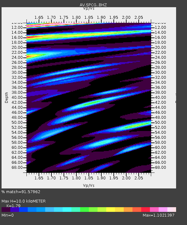
| Estimated Moho Depth: |
10.0 km |
| Estimated Crust Vp/Vs: |
1.79 |
| Assumed Crust Vp: |
6.566 km/s |
| Estimated Crust Vs: |
3.668 km/s |
| Estimated Crust Poisson's Ratio: |
0.27 |
|
| Radial Match: |
91.57962 % |
| Radial Bump: |
400 |
| Transverse Match: |
85.93878 % |
| Transverse Bump: |
400 |
| SOD ConfigId: |
20792311 |
| Insert Time: |
2020-03-05 11:52:58.015 +0000 |
| GWidth: |
2.5 |
| Max Bumps: |
400 |
| Tol: |
0.001 |
|

Signal To Noise
| Channel | StoN | STA | LTA |
| AV:SPCG: :BHZ:20200213T10:40:10.079006Z | 9.984687 | 3.234566E-6 | 3.2395266E-7 |
| AV:SPCG: :BHN:20200213T10:40:10.079006Z | 1.9696276 | 8.536284E-7 | 4.3339583E-7 |
| AV:SPCG: :BHE:20200213T10:40:10.079006Z | 3.343079 | 1.3059833E-6 | 3.9065284E-7 |
| Arrivals |
| Ps | 1.3 SECOND |
| PpPs | 3.9 SECOND |
| PsPs/PpSs | 5.2 SECOND |


