You are here: Home > Network List > AV - Alaska Volcano Observatory Stations List
> Station STLK Strandline Lake, Regional Station, Alaska > Earthquake Result Viewer
STLK Strandline Lake, Regional Station, Alaska - Earthquake Result Viewer
| Earthquake location: |
Kuril Islands |
| Earthquake latitude/longitude: |
45.6/148.9 |
| Earthquake time(UTC): |
2020/02/13 (044) 10:33:44 GMT |
| Earthquake Depth: |
144 km |
| Earthquake Magnitude: |
7.0 mww |
| Earthquake Catalog/Contributor: |
NEIC PDE/us |
|
| Network: |
AV Alaska Volcano Observatory |
| Station: |
STLK Strandline Lake, Regional Station, Alaska |
| Lat/Lon: |
61.50 N/151.83 W |
| Elevation: |
945 m |
|
| Distance: |
37.1 deg |
| Az: |
43.073 deg |
| Baz: |
272.549 deg |
| Ray Param: |
0.07579912 |
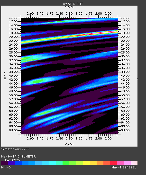
| Estimated Moho Depth: |
17.0 km |
| Estimated Crust Vp/Vs: |
2.09 |
| Assumed Crust Vp: |
6.302 km/s |
| Estimated Crust Vs: |
3.012 km/s |
| Estimated Crust Poisson's Ratio: |
0.35 |
|
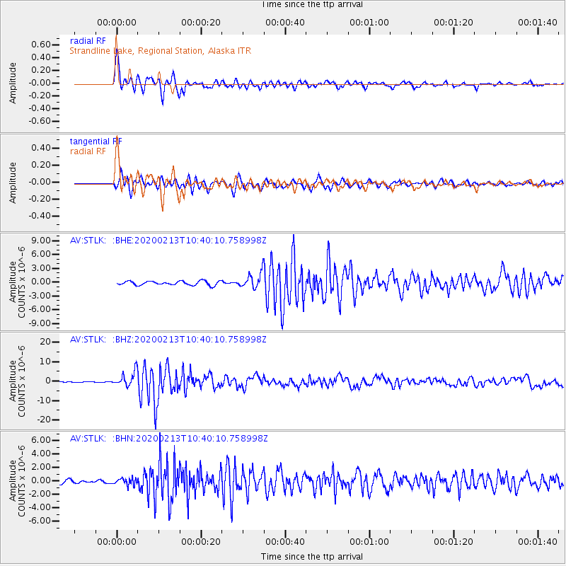
| Radial Match: |
90.9705 % |
| Radial Bump: |
400 |
| Transverse Match: |
85.85682 % |
| Transverse Bump: |
400 |
| SOD ConfigId: |
20792311 |
| Insert Time: |
2020-03-05 11:54:38.340 +0000 |
| GWidth: |
2.5 |
| Max Bumps: |
400 |
| Tol: |
0.001 |
|
Signal To Noise
| Channel | StoN | STA | LTA |
| AV:STLK: :BHZ:20200213T10:40:10.758998Z | 18.41151 | 4.0038794E-6 | 2.1746611E-7 |
| AV:STLK: :BHN:20200213T10:40:10.758998Z | 2.3987367 | 4.7901415E-7 | 1.9969434E-7 |
| AV:STLK: :BHE:20200213T10:40:10.758998Z | 4.388503 | 1.8953118E-6 | 4.3188112E-7 |
| Arrivals |
| Ps | 3.1 SECOND |
| PpPs | 7.9 SECOND |
| PsPs/PpSs | 11 SECOND |


