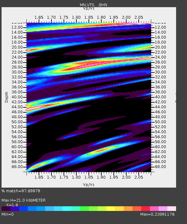
VTS Vitosha, Bulgary - Earthquake Result Viewer
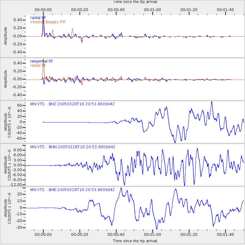
Earthquake location: Northern Sumatra, Indonesia
Earthquake latitude/longitude: 2.1/97.1
Earthquake time(UTC): 2005/03/28 (087) 16:09:36 GMT
Earthquake Depth: 30 km
Earthquake Magnitude: 7.2 MB, 8.4 MS, 8.7 MW, 8.1 MW
Earthquake Catalog/Contributor: WHDF/NEIC
Network: MN MEDNET Project
Station: VTS Vitosha, Bulgary
Lat/Lon: 42.62 N/23.24 E
Elevation: 1490 m
Distance: 76.7 deg
Az: 313.239 deg
Baz: 99.497 deg
Ray Param: 0.05074781
Estimated Moho Depth: 21.0 km
Estimated Crust Vp/Vs: 1.60
Assumed Crust Vp: 6.291 km/s
Estimated Crust Vs: 3.932 km/s
Estimated Crust Poisson's Ratio: 0.18
Radial Match: 97.69979 %
Radial Bump: 250
Transverse Match: 89.88999 %
Transverse Bump: 400
SOD ConfigId: 2459
Insert Time: 2010-03-08 17:57:12.484 +0000
GWidth: 2.5
Max Bumps: 400
Tol: 0.001

Signal To Noise

ChannelStoNSTALTA
MN:VTS: :BHN:20050328T16:20:53.860994Z0.94327474.5542347E-84.828111E-8
MN:VTS: :BHE:20050328T16:20:53.860994Z5.76189476.031877E-71.0468565E-7
MN:VTS: :BHZ:20050328T16:20:53.860994Z4.51862861.2697989E-62.8101422E-7
Arrivals
Ps2.1 SECOND
PpPs8.4 SECOND
PsPs/PpSs10 SECOND