You are here: Home > Network List > CA - Catalan Seismic Network Stations List
> Station CFON Fontmartina > Earthquake Result Viewer
CFON Fontmartina - Earthquake Result Viewer
| Earthquake location: |
Kuril Islands |
| Earthquake latitude/longitude: |
45.6/148.9 |
| Earthquake time(UTC): |
2020/02/13 (044) 10:33:44 GMT |
| Earthquake Depth: |
144 km |
| Earthquake Magnitude: |
7.0 mww |
| Earthquake Catalog/Contributor: |
NEIC PDE/us |
|
| Network: |
CA Catalan Seismic Network |
| Station: |
CFON Fontmartina |
| Lat/Lon: |
41.76 N/2.43 E |
| Elevation: |
973 m |
|
| Distance: |
88.0 deg |
| Az: |
335.591 deg |
| Baz: |
22.803 deg |
| Ray Param: |
0.042599242 |
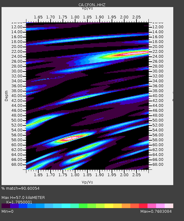
| Estimated Moho Depth: |
57.0 km |
| Estimated Crust Vp/Vs: |
1.79 |
| Assumed Crust Vp: |
5.88 km/s |
| Estimated Crust Vs: |
3.294 km/s |
| Estimated Crust Poisson's Ratio: |
0.27 |
|
| Radial Match: |
90.60054 % |
| Radial Bump: |
400 |
| Transverse Match: |
84.30845 % |
| Transverse Bump: |
400 |
| SOD ConfigId: |
20792311 |
| Insert Time: |
2020-03-05 12:22:02.986 +0000 |
| GWidth: |
2.5 |
| Max Bumps: |
400 |
| Tol: |
0.001 |
|
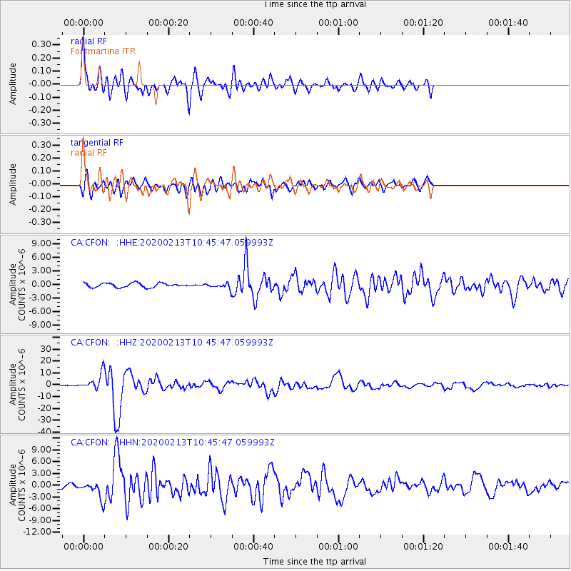
Signal To Noise
| Channel | StoN | STA | LTA |
| CA:CFON: :HHZ:20200213T10:45:47.059993Z | 8.090818 | 6.765839E-6 | 8.362366E-7 |
| CA:CFON: :HHN:20200213T10:45:47.059993Z | 3.4693577 | 2.2218792E-6 | 6.4042956E-7 |
| CA:CFON: :HHE:20200213T10:45:47.059993Z | 1.2153056 | 5.6071093E-7 | 4.613744E-7 |
| Arrivals |
| Ps | 7.7 SECOND |
| PpPs | 27 SECOND |
| PsPs/PpSs | 34 SECOND |


