VTS Vitosha, Bulgary - Earthquake Result Viewer
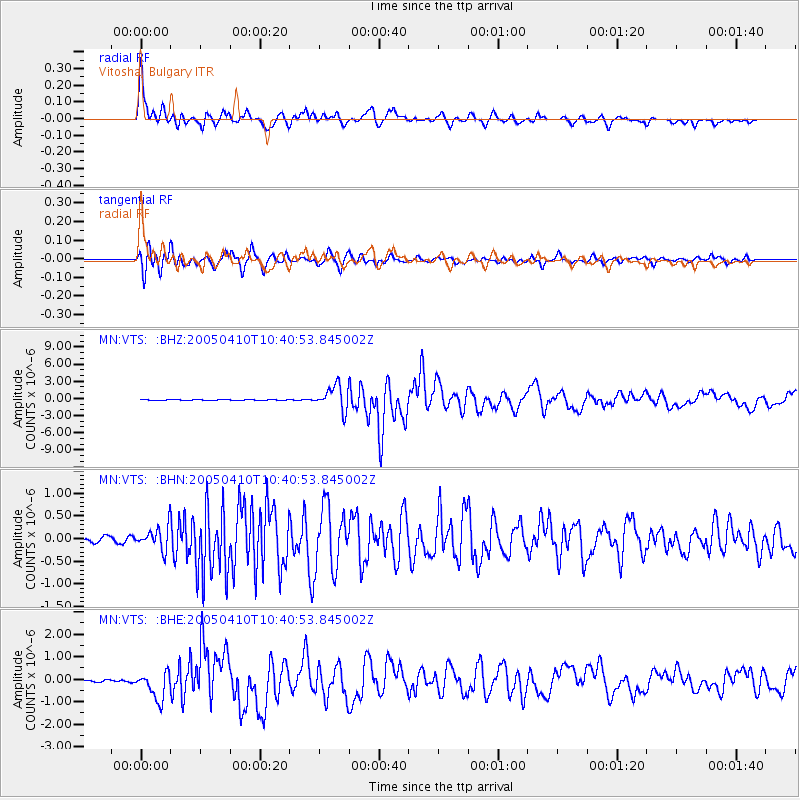
Earthquake location: Southern Sumatra, Indonesia
Earthquake latitude/longitude: -1.6/99.6
Earthquake time(UTC): 2005/04/10 (100) 10:29:11 GMT
Earthquake Depth: 19 km
Earthquake Magnitude: 6.4 MB, 6.7 MS, 6.7 MW, 6.6 MW
Earthquake Catalog/Contributor: WHDF/NEIC
Network: MN MEDNET Project
Station: VTS Vitosha, Bulgary
Lat/Lon: 42.62 N/23.24 E
Elevation: 1490 m
Distance: 81.1 deg
Az: 313.44 deg
Baz: 100.493 deg
Ray Param: 0.047804125
Estimated Moho Depth: 20.75 km
Estimated Crust Vp/Vs: 1.61
Assumed Crust Vp: 6.291 km/s
Estimated Crust Vs: 3.902 km/s
Estimated Crust Poisson's Ratio: 0.19
Radial Match: 94.96095 %
Radial Bump: 400
Transverse Match: 91.03123 %
Transverse Bump: 400
SOD ConfigId: 2459
Insert Time: 2010-03-08 17:57:17.874 +0000
GWidth: 2.5
Max Bumps: 400
Tol: 0.001

Signal To Noise

ChannelStoNSTALTA
MN:VTS: :BHN:20050410T10:40:53.845002Z3.64044362.578946E-77.084154E-8
MN:VTS: :BHE:20050410T10:40:53.845002Z6.31564666.475889E-71.0253722E-7
MN:VTS: :BHZ:20050410T10:40:53.845002Z31.0587252.1144633E-66.807953E-8
Arrivals
Ps2.1 SECOND
PpPs8.4 SECOND
PsPs/PpSs10 SECOND