You are here: Home > Network List > CA - Catalan Seismic Network Stations List
> Station CMAS Mas de Barberans > Earthquake Result Viewer
CMAS Mas de Barberans - Earthquake Result Viewer
| Earthquake location: |
Kuril Islands |
| Earthquake latitude/longitude: |
45.6/148.9 |
| Earthquake time(UTC): |
2020/02/13 (044) 10:33:44 GMT |
| Earthquake Depth: |
144 km |
| Earthquake Magnitude: |
7.0 mww |
| Earthquake Catalog/Contributor: |
NEIC PDE/us |
|
| Network: |
CA Catalan Seismic Network |
| Station: |
CMAS Mas de Barberans |
| Lat/Lon: |
40.73 N/0.31 E |
| Elevation: |
530 m |
|
| Distance: |
89.6 deg |
| Az: |
336.684 deg |
| Baz: |
21.434 deg |
| Ray Param: |
0.041726958 |
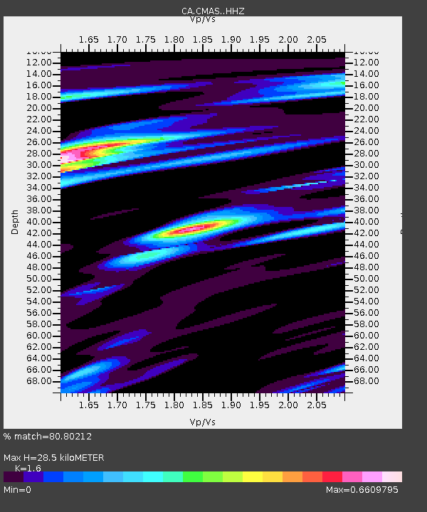
| Estimated Moho Depth: |
28.5 km |
| Estimated Crust Vp/Vs: |
1.60 |
| Assumed Crust Vp: |
6.391 km/s |
| Estimated Crust Vs: |
3.994 km/s |
| Estimated Crust Poisson's Ratio: |
0.18 |
|
| Radial Match: |
80.80212 % |
| Radial Bump: |
400 |
| Transverse Match: |
73.60508 % |
| Transverse Bump: |
400 |
| SOD ConfigId: |
20792311 |
| Insert Time: |
2020-03-05 12:22:25.897 +0000 |
| GWidth: |
2.5 |
| Max Bumps: |
400 |
| Tol: |
0.001 |
|

Signal To Noise
| Channel | StoN | STA | LTA |
| CA:CMAS: :HHZ:20200213T10:45:54.349971Z | 9.4272785 | 3.3988797E-6 | 3.6053672E-7 |
| CA:CMAS: :HHN:20200213T10:45:54.349971Z | 2.7771077 | 1.0227336E-6 | 3.6827294E-7 |
| CA:CMAS: :HHE:20200213T10:45:54.349971Z | 1.5613782 | 6.9700735E-7 | 4.4640518E-7 |
| Arrivals |
| Ps | 2.7 SECOND |
| PpPs | 11 SECOND |
| PsPs/PpSs | 14 SECOND |


