You are here: Home > Network List > CC - Cascade Chain Volcano Monitoring Stations List
> Station PR03 Puyallup River 03 > Earthquake Result Viewer
PR03 Puyallup River 03 - Earthquake Result Viewer
| Earthquake location: |
Kuril Islands |
| Earthquake latitude/longitude: |
45.6/148.9 |
| Earthquake time(UTC): |
2020/02/13 (044) 10:33:44 GMT |
| Earthquake Depth: |
144 km |
| Earthquake Magnitude: |
7.0 mww |
| Earthquake Catalog/Contributor: |
NEIC PDE/us |
|
| Network: |
CC Cascade Chain Volcano Monitoring |
| Station: |
PR03 Puyallup River 03 |
| Lat/Lon: |
46.90 N/122.03 W |
| Elevation: |
523 m |
|
| Distance: |
58.2 deg |
| Az: |
53.757 deg |
| Baz: |
304.377 deg |
| Ray Param: |
0.06254153 |
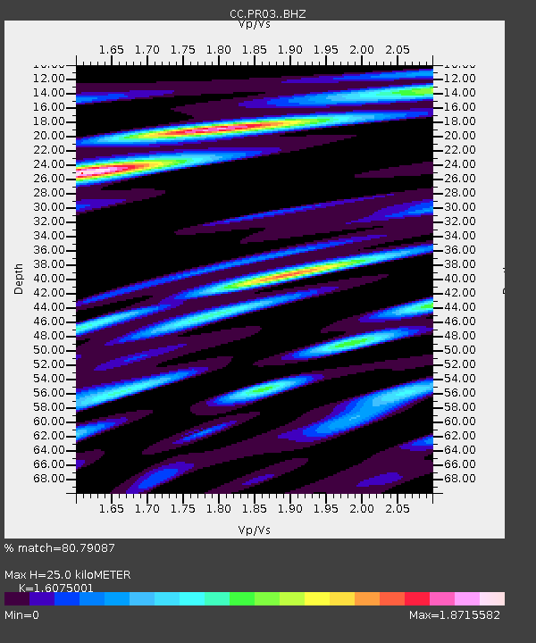
| Estimated Moho Depth: |
25.0 km |
| Estimated Crust Vp/Vs: |
1.61 |
| Assumed Crust Vp: |
6.566 km/s |
| Estimated Crust Vs: |
4.085 km/s |
| Estimated Crust Poisson's Ratio: |
0.18 |
|
| Radial Match: |
80.79087 % |
| Radial Bump: |
400 |
| Transverse Match: |
72.04526 % |
| Transverse Bump: |
400 |
| SOD ConfigId: |
20792311 |
| Insert Time: |
2020-03-05 12:28:21.646 +0000 |
| GWidth: |
2.5 |
| Max Bumps: |
400 |
| Tol: |
0.001 |
|

Signal To Noise
| Channel | StoN | STA | LTA |
| CC:PR03: :BHZ:20200213T10:42:52.919979Z | 3.5705812 | 1.2366951E-6 | 3.463568E-7 |
| CC:PR03: :BHN:20200213T10:42:52.919979Z | 0.928911 | 3.973592E-7 | 4.277689E-7 |
| CC:PR03: :BHE:20200213T10:42:52.919979Z | 3.2595828 | 6.25458E-7 | 1.9188283E-7 |
| Arrivals |
| Ps | 2.4 SECOND |
| PpPs | 9.4 SECOND |
| PsPs/PpSs | 12 SECOND |


