You are here: Home > Network List > CC - Cascade Chain Volcano Monitoring Stations List
> Station PR05 Puyallup River 05 > Earthquake Result Viewer
PR05 Puyallup River 05 - Earthquake Result Viewer
| Earthquake location: |
Kuril Islands |
| Earthquake latitude/longitude: |
45.6/148.9 |
| Earthquake time(UTC): |
2020/02/13 (044) 10:33:44 GMT |
| Earthquake Depth: |
144 km |
| Earthquake Magnitude: |
7.0 mww |
| Earthquake Catalog/Contributor: |
NEIC PDE/us |
|
| Network: |
CC Cascade Chain Volcano Monitoring |
| Station: |
PR05 Puyallup River 05 |
| Lat/Lon: |
46.84 N/121.95 W |
| Elevation: |
1553 m |
|
| Distance: |
58.3 deg |
| Az: |
53.779 deg |
| Baz: |
304.45 deg |
| Ray Param: |
0.062488392 |
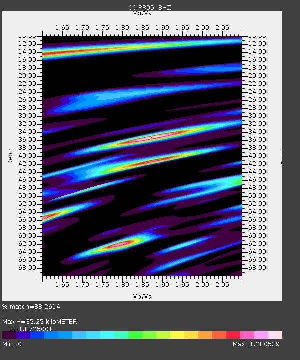
| Estimated Moho Depth: |
35.25 km |
| Estimated Crust Vp/Vs: |
1.87 |
| Assumed Crust Vp: |
6.597 km/s |
| Estimated Crust Vs: |
3.523 km/s |
| Estimated Crust Poisson's Ratio: |
0.30 |
|
| Radial Match: |
88.2614 % |
| Radial Bump: |
400 |
| Transverse Match: |
85.354225 % |
| Transverse Bump: |
400 |
| SOD ConfigId: |
20792311 |
| Insert Time: |
2020-03-05 12:28:38.889 +0000 |
| GWidth: |
2.5 |
| Max Bumps: |
400 |
| Tol: |
0.001 |
|

Signal To Noise
| Channel | StoN | STA | LTA |
| CC:PR05: :BHZ:20200213T10:42:53.499996Z | 5.78793 | 1.177741E-6 | 2.0348224E-7 |
| CC:PR05: :BHN:20200213T10:42:53.499996Z | 1.6500143 | 5.556973E-7 | 3.367833E-7 |
| CC:PR05: :BHE:20200213T10:42:53.499996Z | 1.785069 | 6.703776E-7 | 3.755472E-7 |
| Arrivals |
| Ps | 4.9 SECOND |
| PpPs | 15 SECOND |
| PsPs/PpSs | 20 SECOND |


