You are here: Home > Network List > CC - Cascade Chain Volcano Monitoring Stations List
> Station RUSH Rushingwater Creek > Earthquake Result Viewer
RUSH Rushingwater Creek - Earthquake Result Viewer
| Earthquake location: |
Kuril Islands |
| Earthquake latitude/longitude: |
45.6/148.9 |
| Earthquake time(UTC): |
2020/02/13 (044) 10:33:44 GMT |
| Earthquake Depth: |
144 km |
| Earthquake Magnitude: |
7.0 mww |
| Earthquake Catalog/Contributor: |
NEIC PDE/us |
|
| Network: |
CC Cascade Chain Volcano Monitoring |
| Station: |
RUSH Rushingwater Creek |
| Lat/Lon: |
46.90 N/121.94 W |
| Elevation: |
1235 m |
|
| Distance: |
58.3 deg |
| Az: |
53.717 deg |
| Baz: |
304.421 deg |
| Ray Param: |
0.062509164 |
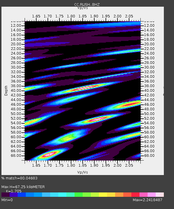
| Estimated Moho Depth: |
67.25 km |
| Estimated Crust Vp/Vs: |
1.71 |
| Assumed Crust Vp: |
6.597 km/s |
| Estimated Crust Vs: |
3.87 km/s |
| Estimated Crust Poisson's Ratio: |
0.24 |
|
| Radial Match: |
80.04683 % |
| Radial Bump: |
400 |
| Transverse Match: |
86.90235 % |
| Transverse Bump: |
400 |
| SOD ConfigId: |
20792311 |
| Insert Time: |
2020-03-05 12:28:55.051 +0000 |
| GWidth: |
2.5 |
| Max Bumps: |
400 |
| Tol: |
0.001 |
|

Signal To Noise
| Channel | StoN | STA | LTA |
| CC:RUSH: :BHZ:20200213T10:42:53.280025Z | 5.3900537 | 1.7339291E-6 | 3.2169052E-7 |
| CC:RUSH: :BHN:20200213T10:42:53.280025Z | 4.6378207 | 1.3929418E-6 | 3.0034406E-7 |
| CC:RUSH: :BHE:20200213T10:42:53.280025Z | 1.4333379 | 7.228501E-7 | 5.0431237E-7 |
| Arrivals |
| Ps | 7.6 SECOND |
| PpPs | 26 SECOND |
| PsPs/PpSs | 34 SECOND |


