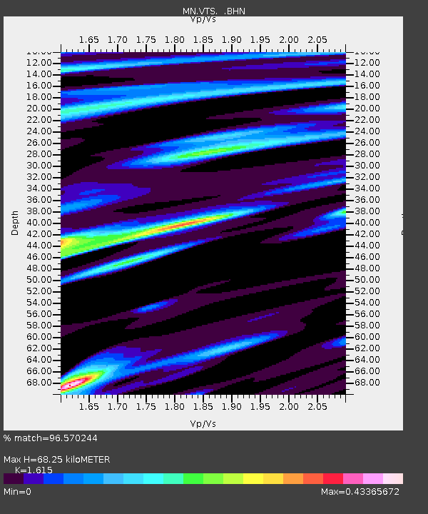
VTS Vitosha, Bulgary - Earthquake Result Viewer

Earthquake location: Northern Sumatra, Indonesia
Earthquake latitude/longitude: 0.6/98.5
Earthquake time(UTC): 2005/05/14 (134) 05:05:18 GMT
Earthquake Depth: 34 km
Earthquake Magnitude: 6.4 MB, 6.8 MS, 6.8 MW, 6.8 MW
Earthquake Catalog/Contributor: WHDF/NEIC
Network: MN MEDNET Project
Station: VTS Vitosha, Bulgary
Lat/Lon: 42.62 N/23.24 E
Elevation: 1490 m
Distance: 78.7 deg
Az: 313.304 deg
Baz: 99.658 deg
Ray Param: 0.049383298
Estimated Moho Depth: 68.25 km
Estimated Crust Vp/Vs: 1.62
Assumed Crust Vp: 6.291 km/s
Estimated Crust Vs: 3.896 km/s
Estimated Crust Poisson's Ratio: 0.19
Radial Match: 96.570244 %
Radial Bump: 400
Transverse Match: 91.635826 %
Transverse Bump: 400
SOD ConfigId: 2455
Insert Time: 2010-03-08 17:57:24.521 +0000
GWidth: 2.5
Max Bumps: 400
Tol: 0.001

Signal To Noise

ChannelStoNSTALTA
MN:VTS: :BHN:20050514T05:16:46.508015Z5.1623421.2717945E-72.4635995E-8
MN:VTS: :BHE:20050514T05:16:46.508015Z23.1860686.609718E-72.8507284E-8
MN:VTS: :BHZ:20050514T05:16:46.508015Z45.3496551.9457907E-64.2906407E-8
Arrivals
Ps6.9 SECOND
PpPs28 SECOND
PsPs/PpSs34 SECOND