You are here: Home > Network List > CC - Cascade Chain Volcano Monitoring Stations List
> Station STD Studebaker Ridge, Mount St. Helens > Earthquake Result Viewer
STD Studebaker Ridge, Mount St. Helens - Earthquake Result Viewer
| Earthquake location: |
Kuril Islands |
| Earthquake latitude/longitude: |
45.6/148.9 |
| Earthquake time(UTC): |
2020/02/13 (044) 10:33:44 GMT |
| Earthquake Depth: |
144 km |
| Earthquake Magnitude: |
7.0 mww |
| Earthquake Catalog/Contributor: |
NEIC PDE/us |
|
| Network: |
CC Cascade Chain Volcano Monitoring |
| Station: |
STD Studebaker Ridge, Mount St. Helens |
| Lat/Lon: |
46.24 N/122.22 W |
| Elevation: |
1189 m |
|
| Distance: |
58.5 deg |
| Az: |
54.49 deg |
| Baz: |
304.623 deg |
| Ray Param: |
0.062370714 |
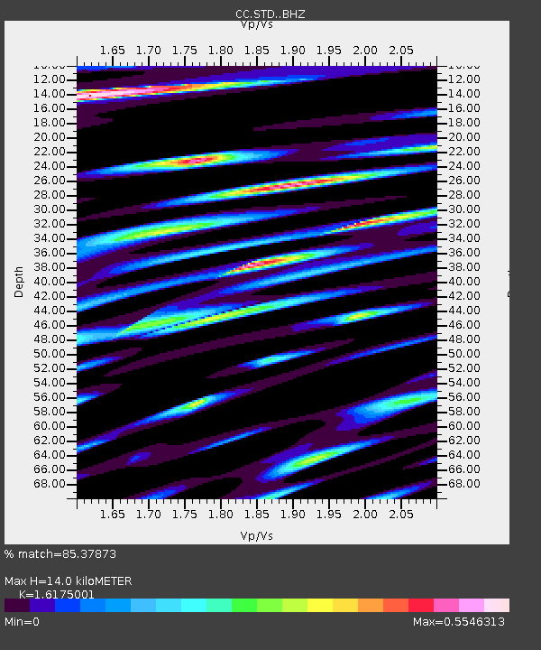
| Estimated Moho Depth: |
14.0 km |
| Estimated Crust Vp/Vs: |
1.62 |
| Assumed Crust Vp: |
6.566 km/s |
| Estimated Crust Vs: |
4.059 km/s |
| Estimated Crust Poisson's Ratio: |
0.19 |
|
| Radial Match: |
85.37873 % |
| Radial Bump: |
400 |
| Transverse Match: |
84.9377 % |
| Transverse Bump: |
400 |
| SOD ConfigId: |
20792311 |
| Insert Time: |
2020-03-05 12:29:31.256 +0000 |
| GWidth: |
2.5 |
| Max Bumps: |
400 |
| Tol: |
0.001 |
|

Signal To Noise
| Channel | StoN | STA | LTA |
| CC:STD: :BHZ:20200213T10:42:54.78503Z | 9.837414 | 2.0803361E-6 | 2.1147184E-7 |
| CC:STD: :BHN:20200213T10:42:54.78503Z | 5.128466 | 1.1465291E-6 | 2.235618E-7 |
| CC:STD: :BHE:20200213T10:42:54.78503Z | 1.694726 | 7.142274E-7 | 4.214412E-7 |
| Arrivals |
| Ps | 1.4 SECOND |
| PpPs | 5.3 SECOND |
| PsPs/PpSs | 6.7 SECOND |


