You are here: Home > Network List > CI - Caltech Regional Seismic Network Stations List
> Station SMM Simmler, CA, USA > Earthquake Result Viewer
SMM Simmler, CA, USA - Earthquake Result Viewer
| Earthquake location: |
Kuril Islands |
| Earthquake latitude/longitude: |
45.6/148.9 |
| Earthquake time(UTC): |
2020/02/13 (044) 10:33:44 GMT |
| Earthquake Depth: |
144 km |
| Earthquake Magnitude: |
7.0 mww |
| Earthquake Catalog/Contributor: |
NEIC PDE/us |
|
| Network: |
CI Caltech Regional Seismic Network |
| Station: |
SMM Simmler, CA, USA |
| Lat/Lon: |
35.31 N/120.00 W |
| Elevation: |
599 m |
|
| Distance: |
66.5 deg |
| Az: |
63.106 deg |
| Baz: |
310.077 deg |
| Ray Param: |
0.057190537 |
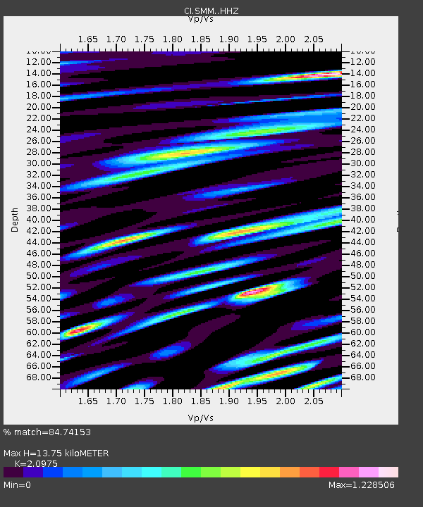
| Estimated Moho Depth: |
13.75 km |
| Estimated Crust Vp/Vs: |
2.10 |
| Assumed Crust Vp: |
6.1 km/s |
| Estimated Crust Vs: |
2.908 km/s |
| Estimated Crust Poisson's Ratio: |
0.35 |
|
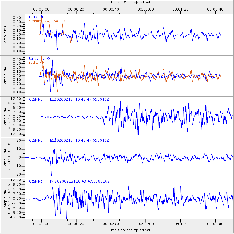
| Radial Match: |
84.74153 % |
| Radial Bump: |
400 |
| Transverse Match: |
84.59534 % |
| Transverse Bump: |
400 |
| SOD ConfigId: |
20792311 |
| Insert Time: |
2020-03-06 14:18:37.653 +0000 |
| GWidth: |
2.5 |
| Max Bumps: |
400 |
| Tol: |
0.001 |
|
Signal To Noise
| Channel | StoN | STA | LTA |
| CI:SMM: :HHZ:20200213T10:43:47.658016Z | 5.9531226 | 1.653583E-6 | 2.7776736E-7 |
| CI:SMM: :HHN:20200213T10:43:47.658016Z | 1.4881752 | 1.0106608E-6 | 6.791276E-7 |
| CI:SMM: :HHE:20200213T10:43:47.658016Z | 1.3168334 | 5.6955577E-7 | 4.3251924E-7 |
| Arrivals |
| Ps | 2.5 SECOND |
| PpPs | 6.8 SECOND |
| PsPs/PpSs | 9.3 SECOND |


