You are here: Home > Network List > CI - Caltech Regional Seismic Network Stations List
> Station VES Vestal, Richgrove, CA, USA > Earthquake Result Viewer
VES Vestal, Richgrove, CA, USA - Earthquake Result Viewer

| Earthquake location: |
Kuril Islands |
| Earthquake latitude/longitude: |
45.6/148.9 |
| Earthquake time(UTC): |
2020/02/13 (044) 10:33:44 GMT |
| Earthquake Depth: |
144 km |
| Earthquake Magnitude: |
7.0 mww |
| Earthquake Catalog/Contributor: |
NEIC PDE/us |
|
| Network: |
CI Caltech Regional Seismic Network |
| Station: |
VES Vestal, Richgrove, CA, USA |
| Lat/Lon: |
35.84 N/119.08 W |
| Elevation: |
154 m |
|
| Distance: |
66.7 deg |
| Az: |
62.146 deg |
| Baz: |
310.223 deg |
| Ray Param: |
0.057052795 |
| Estimated Moho Depth: |
35.5 km |
| Estimated Crust Vp/Vs: |
1.96 |
| Assumed Crust Vp: |
6.1 km/s |
| Estimated Crust Vs: |
3.116 km/s |
| Estimated Crust Poisson's Ratio: |
0.32 |
|
| Radial Match: |
89.75711 % |
| Radial Bump: |
370 |
| Transverse Match: |
77.97513 % |
| Transverse Bump: |
356 |
| SOD ConfigId: |
20792311 |
| Insert Time: |
2020-03-06 14:22:50.483 +0000 |
| GWidth: |
2.5 |
| Max Bumps: |
400 |
| Tol: |
0.001 |
|
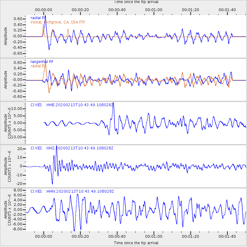
Signal To Noise
| Channel | StoN | STA | LTA |
| CI:VES: :HHZ:20200213T10:43:49.108028Z | 29.467262 | 5.6305907E-6 | 1.9107954E-7 |
| CI:VES: :HHN:20200213T10:43:49.108028Z | 1.2145833 | 9.825831E-7 | 8.089878E-7 |
| CI:VES: :HHE:20200213T10:43:49.108028Z | 1.6387239 | 1.5191947E-6 | 9.270596E-7 |
| Arrivals |
| Ps | 5.8 SECOND |
| PpPs | 17 SECOND |
| PsPs/PpSs | 22 SECOND |


